Aït Bougoumez valley


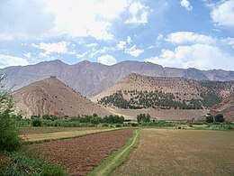
The Aït Bougoumez Valley (also Aït Bouguemez Valley ) is a mountain valley on the north side of the High Atlas in the province of Azilal in the region Beni Mellal-Khénifra in Morocco . Because of its fertility - two harvests are possible depending on the winter snow or rainfalls - and because of its balanced climate, it has been nicknamed vallée heureuse 'happy valley' .
location
The Aït Bougoumez valley, which is about 1800 m to 1900 m high, begins about 30 km southeast of Azilal and stretches for another 25 km in a southerly direction to Agouti and Tabant or Ibakliwin . A few kilometers further south rises the elongated, over 4000 m high Jbel M'Goun massif.
population
The approximately 14,000 inhabitants of the valley are almost exclusively of Berber descent and live in more than 30 villages; the largest town and administrative center is Tabant, where there is also a weekly market. The regional dialect of the Central Atlas Tamazight is spoken , but also Moroccan Arabic and a little French.
economy
For centuries the economy of the remote but fertile valley was geared towards self-sufficiency and self-sufficiency; Markets were simply too far away and donkeys were the only means of transport. A system of strict controls ( agdal ), which was strictly based on the availability, individual needs and the common use of natural resources (water, soil, wood, etc.) enabled the inhabitants of the high valley to survive successfully and sustainably.
history
Despite the lack of written records, it can be assumed that the high valley has been inhabited for centuries, although in earlier centuries there must have been a constant conflict between migrating cattle nomads and settled farmers about food resources, which was certainly often only resolved by force. In the early 20th century, the residents were still largely cut off from the outside world - a situation that only changed with improved transport options and increasing tourism. However, in many respects the valley is still quite pristine.
Attractions
Like the Ourika Valley , the Aït Bougoumez Valley offers not only its scenic beauty, but also diverse insights into the life and culture of the Berbers of the High Atlas.
- The round Agadir Sidi Moussa above the village of Timit is one of the strangest and most imposing buildings of its kind in all of Morocco.
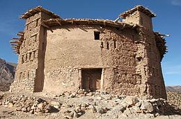
- Many villages (including Timit and Ibakliwin ) still have some inhabited mud houses; however, others have already been abandoned and replaced by new buildings made of hollow blocks and concrete ceilings.
- Agadir Sidi Chita , located on a hilltop about 4 km from Timit, is only partially preserved.
- The Ibakliwin Kasbah is a kind of defense and storage tower on a square floor plan.
- At Ibakliwin there are also several boulders with dinosaur tracks.
- The approximately 30 km long path to Zaouiat Ahansal can be driven with off-road vehicles or hiked.
Trekking
Various hikes and trekking tours are possible from the Aït Bougoumez valley. One of the longest is a three-day tour from Agouti to Jbel M'Goun ( 4068 m ), which is usually undertaken in spring and summer . Other technically demanding tours lead through the mountains of the High Atlas to Imlil or via Zaouiat Ahansal into the Anergui Valley .
Web links
- Ait Bougoumez Valley - excellent photos + brief information (French)
- Ait Bougoumez valley - photo
- Ait Bougoumez Valley - video , arte (French)
Coordinates: 31 ° 39 ′ 20 ″ N , 6 ° 26 ′ 0 ″ W.


