Azilal (province)
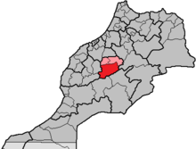
The province of Azilal, which is about 9800 km² and has around 520,000 inhabitants ( Arabic إقليم أزيلال, DMG Iqlīm Azīlāl , Central Atlas Tamazight ⵜⴰⵙⴳⴰ ⵏ ⴰⵣⵉⵍⴰⵍ Tasga n Aẓilal ) has been part of the Moroccan region of Béni Mellal-Khénifra (previously Tadla-Azilal ) since 2015 . The capital of the province is the city of Azilal .
geography
location
The province of Azilal borders in the northwest with the province of Fquih Ben Salah , in the northeast with the province Beni Mellal , in the east with the province Midelt , in the southeast with the province Tinghir , in the southwest with the provinces Ouarzazate and Al Haouz and in the northwest with the province El Kelaâ des Sraghna .
landscape
The province of Azilal is located in the center of Morocco on the north face of the High Atlas . The two main towns Azilal and Demnate are at an altitude of approx. 1370 m and 970 m above sea level. d. M .. Further south are the high valleys of the Aït Bougoumez valley and the Anergui valley , which are approx. 1800 m and approx. 1500 m high . The 3500 to 4100 m high chain of peaks of the High Atlas, which also forms the southern border of the province, extends even further south.
climate
Due to the altitude, the maximum daily temperatures in summer rarely exceed 30 ° C; At night it cools down to 10 to 15 ° C when it is cloudy. In winter, frost levels can also be reached, but during the day temperatures are usually around 15 to 20 ° C. Rain, and snow in the mountains, actually only falls in the winter months from October to February.
Larger places (selection)
CU = Commune Urbaine / CR = Commune Rurale
| local community | Residents | |
|---|---|---|
| 2nd September 1994 | September 2, 2004 | |
| Azilal (CU) | 18,080 | 27,719 |
| Demnate (CU) | 17,782 | 23,459 |
| Aït M'hamed (CR) | 18,888 | 21,742 |
| Afourar (CR) | 16,148 | 20,082 |
| Anergui (CR) | 3,007 | 3,362 |
| Bzou (CR) | 15,246 | 14,507 |
| Foum Jamaa (CR) | 9,041 | 9,658 |
| Ouaouizeght (CR) | 11,954 | 13,940 |
| Tabant (CR) | 11,598 | 13,012 |
| Zaouiat Ahansal (CR) | 8,882 | 10,435 |
population
A large part of the more than 90% of the population of Berber origin lives in rural regions (approx. 75%), but due to the climatic and socio-culturally-related high levels of rural exodus , the proportion of the urban population has increased significantly since the 1970s (approx. 25%) and will continue to rise.
economy


Agriculture traditionally plays the central role in the economic life of the province; However, with the improved transport conditions since the 1970s, the share of urban handicrafts and retailers in economic output has increased. Tourism still plays a very subordinate role.
history
Since there are hardly any verifiable written sources from the Berber regions of Morocco, one can only draw conclusions from the way of life of the various Berber tribes during the early French colonial period , some of which survived into the early 21st century. After that there were long-lasting, sometimes warlike, conflicts between settled and nomadic tribes in the mountain regions of Morocco, of which the few preserved fortified and storage castles ( agadirs ) bear testimony.
Attractions
Scenic sights are the natural rock gate Imi-n-Ifri near Demnate, the Cascades d'Ouzoud waterfalls west of Azilal and the two high valleys mentioned. The fortified and storage castles of Agadir Sidi Moussa near Timit and the square-cubic tower near Ibakliwin in the Aït Bougoumez valley are of cultural interest . The typical clay villages of the High Atlas with their single-storey houses are gradually being abandoned by the residents and replaced by new buildings made of hollow blocks and concrete.

