Al Haouz


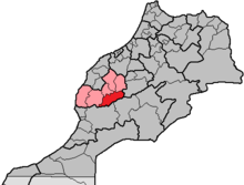
Al Haouz ( Arabic إقليم الحوز, DMG Iqlīm al-Ḥauz , Taschelhit ⵜⴰⵙⴳⴰ ⵏ ⵍⵃⴰⵡⵣ ) is a province in the center of the High Atlas in Morocco . Since the administrative reform of 2015, it has belonged to the Marrakech-Safi region (previously Marrakech-Tensift-Al Haouz ) and is located in the south of the country, not far from Marrakech . The province has approx. 575,000 inhabitants (2014) with an area of approx. 5,100 km².
geography
location
The province of Al-Haouz borders the province of Chichaoua in the west, the prefecture of Marrakech in the north-west, the provinces Rehamna and El Kelaâ des Sraghna in the north, the province Azilal in the east, the province Ouarzazate in the south-east and the Taroudant Province .
landscape
The province of Al Haouz includes the highest mountain regions of Morocco, ie the area of the 4167 m high Jbel Toubkal and the 4089 m high Jbel Ouanoukrim . The inhabited places are mostly at altitudes between 1000 and 2000 m .
Rivers
Several rivers and streams are fed by the meltwater of the High Atlas - the most important are the Oued Tensift and its tributaries Oued Ourika and Oued Nfiss .
climate
The altitude results in comparatively low temperatures, which can drop well below freezing on winter nights, while during the day 10 ° to 20 ° are usually reached. In summer, the 30 ° limit is rarely exceeded. Precipitation actually only falls in the winter months from November to February; the snow line is around 3000 m.
Population, Economy and History
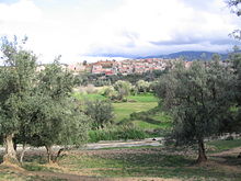
The area, which is mostly around 1000 to 2000 m high, served for thousands of years for hunting and later as a summer pasture for wandering Berber nomads . The gradual process of settling down probably only began around 500 to 1000 years ago - small houses were built from stone and earth with roofs made from wood, reeds and an earth cover, and plots in the valley and hillside areas were built as cultivation areas for barley and vegetables (onions, Carrots, beans). The people lived as self-sufficient ; It was not until the 20th century that the old paths were converted into slopes, most of which are now paved.
Population development
| year | 1994 | 2004 | 2014 |
|---|---|---|---|
| Residents | 435.090 | 484.312 | 573.128 |
Attractions
Apart from the impressive mountain landscape - especially in spring - which is particularly evident in the Ourika Valley and the Oued Nfiss Valley , the province is home to one of the country's oldest and most impressive mosques - the Tinmal Mosque . The prehistoric rock carvings in the Jbel Yagour and Oukaïmeden areas also deserve attention.
One of the most beautiful trekking tours in Morocco leads from Imlil to Setti Fatma . The Jbel Toubkal , the Jbel Ouanoukrim and other peaks in their vicinity can be climbed in mostly three-day mountain tours.
Biggest places
The places marked with (M) are classified as urban settlements (Municipalités) ; the rest are considered rural communities (communes rurales) and consist of several villages.
| local community | Residents | ||
|---|---|---|---|
| 1994 | 2004 | 2014 | |
| Ait Ourir (M) | 12,162 | 20.005 | 39,108 |
| Ait Faska | 16,210 | 19,239 | 26,210 |
| Ait Sidi Daoud | 17.307 | 19,286 | 18,976 |
| Amizmiz | 11,919 | 13,711 | 14,364 |
| Asni | 16,252 | 18,674 | 21,244 |
| Ghmate | 20,460 | 22.805 | 25,220 |
| Ijoukak | 6,305 | 6,641 | 6,700 |
| Moulay Brahim | 10,503 | 10,979 | 11,813 |
| Oukaïmeden | 3,798 | 4,440 | 4,861 |
| Ourika | 21,982 | 26,990 | 37,316 |
| Setti Fatma | 20,545 | 22,283 | 24,129 |
| Sidi Abdallah Ghiat | 16,298 | 20,649 | 29,498 |
| Tahannaout | 5,697 | 6,585 | 12,102 |
| Tameslohte | 17,138 | 21,408 | 28,978 |
| Tidili Mesfioua | 22,056 | 21,106 | 21,706 |
| Tighedouine | 20,939 | 22,353 | 22,971 |
| Cringed | 18,239 | 19,154 | 19,926 |
Web links
Individual evidence
- ↑ Population statistics Morocco ( Memento from March 3, 2016 in the Internet Archive )
- ↑ Statistics Province of Al Haouz


