Imlil (High Atlas)
| Imlil | ||||
|---|---|---|---|---|
|
||||
| Basic data | ||||
| State : |
|
|||
| Region : | Marrakech-Safi | |||
| Province : | Al Haouz | |||
| Coordinates | 31 ° 8 ′ N , 7 ° 55 ′ W | |||
| Residents : | 800 | |||
| Height : | 1750 m | |||
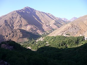
| Imlil in a valley of the High Atlas | ||||
Imlil ( Central Atlas Tamazight ⵉⵎⵍⵉⵍ Timlil ) is a small mountain village ( douar ) in the center of the High Atlas in the province of Al Haouz in the region Marrakech-Safi in Morocco . It belongs to the rural community ( commune rurale ) of Asni .
location
Imlil is about 65 km (driving distance) south of the city of Marrakech in a partially wooded valley of the High Atlas at an altitude of about 1700 to 1800 m . The place can be easily reached from Marrakech via the R203 and the P2005 (from Asni ). The small brook Oued Rheraya rises in the Toubkal massif, flows through Imlil and Asni and seeps into the plain south of Marrakech. Imlil's climate is alpine; Rain (approx. 540 mm / year) falls mainly in the winter months.
tourism
The small Berber settlement has grown more and more with increasing trekking and mountain tourism since the 1960s. Imlil is the starting point for mostly three-day mountain tours (two half days for the ascent; half a day for the descent) to the 4167 m high Toubkal , the highest peak in Morocco and all of North Africa. Other tours lead along the mountains to Setti Fatma in the Ourika Valley or to Agouti in the Aït Bougoumez Valley .
In December 2018, the decapitated corpses of Scandinavian tourists Louisa Vesterager Jespersen and Maren Ueland were found there.
Others
Imlil was the location for some scenes from the feature films
- Kundun ; (1997); Director: Martin Scorsese
- Seven years in Tibet ; (1997); Director: Jean-Jacques Annaud ; Leading actor: Brad Pitt .


