High Atlas
| High Atlas | ||
|---|---|---|
| Highest peak | Toubkal ( 4167 m ) | |
| location | Morocco | |
| part of | Atlas Mountains | |
|
|
||
| Coordinates | 31 ° 4 ′ N , 7 ° 55 ′ W | |

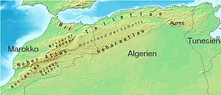
The High Atlas ( Arabic الأطلس الكبير, DMG al-Aṭlas al-kabīr ) in southern Morocco is the highest mountain range in the Atlas . To the east, the Tell Atlas and the Sahara Atlas , which largely belong to Algeria, join.
geography
The High Atlas rises from the west on the Atlantic coast in an easterly direction to the Moroccan-Algerian border, where it still reaches heights of 2500 m. Further east, heights of 2000 m are rarely exceeded. It drops steeply towards the Atlantic and southwest towards the Souss plain and forms an impressive contrast to the coast and the Anti-Atlas . To the north, in the direction of Marrakech , it drops off less abruptly. It is the west-east running Moroccan weather divide against the Saharan climatic influences, which are particularly moderated in summer.
In Morocco, the High Atlas forms the basis for a large number of river systems and thus also for large agricultural regions south of the mountains ( Souss plain ), but even more towards the north ( Tadla plain ).
The highest peak, the Toubkal , reaches 4167 m. The second highest mountain, the Jbel Ouanoukrim, is only 5 km (as the crow flies) away and reaches 4089 m. About 170 km further east-northeast is the elongated M'Goun massif with a maximum height of 4071 m. Snow falls regularly on the high altitudes, which remains until spring and opens up opportunities for winter sports (e.g. in Oukaïmeden ).
Attractions
Detours from the road over the Tizi n'Tichka pass (2260 m) lead to Ait Benhaddou with its residential castles made of clay ( Tighremts ) and further on a single-lane road, which has now been paved, to Tazlaft (cave storage facility ) and Anemiter to Telouet ( Kasbah of El Glaoui ). The worth seeing Agadir (storage castle ) of Igherm n'Ougdal is located directly on the main route.
The spectacular, but not entirely harmless road over the Tizi n'Test -Pass (2093 m) due to frequent landslides passes the small town of Tinmal on the other side of a mountain stream with the mosque from Almohadic times (approx. 1153/54), which is also accessible to tourists .
Many fertile valleys are embedded in the northern flank of the High Atlas (south of Beni Mellal ) (including the Ourika valley , the Aït Bougoumez valley , the Ahansal valley and the Anergui valley ). A number of agadirs (see Timit ) and a very traditional way of life of the local Berber tribes have been preserved here.
The spectacular Dadès Gorge (north of Boumalne Dadès ) with its ancient residential castles ( Tighremts ) (e.g. Aït Arbi , Aït Youl ) is located on the south side, which is more developed in terms of traffic and tourism . Further to the east, the Todra (or Todghra ) river cuts through the rocky mountains and forms the scenic gorge of the same name (north of Tinghir ); in the further course, numerous date palm oases line the mostly dried up river bed.
Trekking
In many places on both sides of the mountain range, local organizers offer hiking and trekking tours almost all year round, where the beauty and originality of the landscape are impressive. The Jbel Toubkal (4167 m) and the Jbel M'Goun (4071 m) can also be climbed almost all year round . A three-day mountain hike leads from Imlil to Setti Fatma in the Ourika Valley .
Minerals
The High Atlas is known to mineral lovers as a place where rare minerals are found. Minerals of all kinds (including forgeries) are for sale in small stalls to the left and right of the pass roads.
gallery
Todra Canyon
literature
- Louis Werner: Across the High Atlas. Saudi Aramco World, March / April 1993 (Weblink: http://www.saudiaramcoworld.com/issue/199302/across.the.high.atlas.htm )


