Anti Atlas
| Anti Atlas | ||
|---|---|---|
|
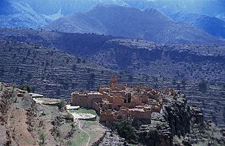
Tioulit - a largely abandoned town in the western Anti-Atlas with previously used circular threshing areas |
||
| location | Morocco | |
| part of | Atlas Mountains | |
|
|
||
| Coordinates | 30 ° 0 ′ N , 8 ° 30 ′ W | |
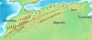
The Anti Atlas ( Arabic الأطلس الصغير, DMG al-Aṭlas aṣ-ṣaġīr = "little atlas"; Central Atlas Tamazight ⴰⴷⵔⴰⵔ ⵎⵥⵥⵉⵢⵏ Adrar Mẓẓiyen ) is the southernmost of the three - mostly in Morocco lying - mountain ranges of the Atlas Mountains in northwest Africa.
geography
The Anti-Atlas stretches from the Atlantic in the south-west to the north-east up to the level of Ouarzazate and further east to the Tafilalet (a total of around 500 km). In the south it is bounded by the northern foothills of the Sahara . The mountain massifs of Jbel Sirwa and Djebel Sarhro and their foothills are of volcanic origin and thus geologically independent, and in parts they approach the High Atlas and are only separated from it by narrow valleys such as the Dadès Valley and the Todra Valley . At the height of Ouarzazate, the massif is cut by the Wadi Draa in a southerly direction. The mountain peaks of the Anti Atlas reach maximum heights of over 2500 m ( Jbel Aklim ); some mountains are around 2300 m high (e.g. Jbel Lekst ) compared to an average height of around 1000 to 1200 m. The mountains are particularly rugged towards the south to the approximately 700 m high level of the Sahara . The Jbel Sirwa volcano is significantly higher. It reaches a maximum height of 3304 m.
geology


From a geological point of view, the African Plate begins with the Anti-Atlas . This originated in the Precambrian and is therefore geologically older than the European continental plate, to which the neighboring mountain chains of the Middle and High Atlas also belong. On the basement of Africa, fossil-free Precambrian (older than 570 million years) and Cambrian rocks form the anti-Atlas, which was formed in the Upper Paleozoic (about 500 million years ago). In this geological phase, the two continents Laurussia and Gondwana collided . In this temporal and geological context, the mountains of the Anti Atlas were created. The granite formations of volcanic origin that characterize the landscape around the town of Tafraoute date from a later period .
After the formation of the High Atlas, mainly in the Eocene (began around 55 million years ago), volcanic eruptions occurred in the weak zones between the two mountains. The Jbel Sirwa (or Jbel Siroua ) and the area of the Jbel Sarhro , whose highest point, the Jbel Amalou n'Mansour , reaches a height of 2712 m are of volcanic origin. Thermal springs and earthquakes still testify today that the area of the Atlas Mountains has not yet come to rest geologically.
places
The largest places in the Anti-Atlas are mountain oases like Aït Baha , Tafraoute and Igherm ; smaller places like Aït Kine are remote and rarely visited. In the southern and eastern foothills of the mountains there are several oasis settlements, including Taghjijt , Amtoudi , Akka , Tata , Foum Zguid and Tazenakht .
climate
Climatically, the eastern part of the mountains must be assigned to the stone desert zone ( hammada ) of the pre-Sahara . The area of the Anti-Atlas is generally warm to hot; In the south of the Anti-Atlas, the amount of precipitation is less than 200 mm per year, while the climatic conditions on the north and west flanks are somewhat more favorable.
flora
While the west and north on large areas of thyme , rosemary , asphodel and other drought and UV rays gefeite plants such Arganienbäume , almond trees , succulents and cacti steppe like the Anti-Atlas cover (threatened by overgrazing ) are in the south and east - apart from some few palm oases - at most thorn bushes to be found. The transition to semi-desert and desert is fluid.
Settlement and economy
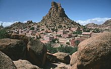
Traditionally, the Anti-Atlas is the Schlöh - Berbers inhabited. Its center is the town of Tafraoute , which, together with the nearby Ammeln Valley, is a popular tourist destination. The native language of the population of the Western Anti-Atlas is Taschelhit , a Berber language that has been taught in Moroccan state schools since 2003. In the Eastern Anti-Atlas, however, Tamazight is spoken. Due to the difficult conditions for agricultural production (stony soils, low rainfall, high daytime temperatures, high UV radiation) and the low earning potential, rural exodus is a significant problem in the Anti-Atlas. The able-bodied men often earn their living in the big cities in the north Morocco ( Casablanca , Rabat , Tangier and others) or in Europe and in this way feed the families who have stayed in the mountain villages. The illiteracy rate is estimated here at 75%. Individual tourism has developed into a not inconsiderable economic factor over the last few decades.
As a rule, areas along rivers and streams are usually inhabited and used for agriculture, but these areas have no water for most of the year ( oueds ) . On the plateaus or on some of the hillside terraces that are still being worked on, barley is sometimes grown with very low yields or cattle-breeding (goats, sheep) is practiced to a small extent.
Landscape image
The largely arid Anti-Atlas is very different from the other two atlas chains in Morocco, the Middle and High Atlas. While the extreme west of the Anti-Atlas, which slopes towards the Atlantic, can be described as comparatively fertile due to higher winter rainfall, the mountains towards the east are becoming increasingly dry and therefore more sterile - the transition to the stone desert is fluid. In earlier times agriculture was only possible here with great difficulty and with very little yield and so the inhabitants lived mostly as semi-nomads ( transhumants ); In some places the mostly abandoned terrace fields and threshing areas can still be seen . The roads from Tafraoute or Taroudannt to Igherm and on to Tata , which were completed after the turn of the millennium, lead through almost deserted, but extremely impressive landscapes that are rarely interrupted by oasis valleys .
Culture
The most important cultural sights in the Anti-Atlas are undoubtedly the numerous Stone Age rock carvings in the Draâ Valley and elsewhere, which are difficult to find without a local guide . The storage castles ( agadires ) of the various Berber tribes, mostly made of small to medium-sized stones and a little bit of earth, date from a much later period ; In addition, the traditional residential castles ( Tighremts ) in the vicinity of Tafraoute (Tazka, Aday, Oumesnat) , which are largely built of rammed earth but have already been badly destroyed or in rapid decline , are of tourist interest. A few have been converted into small “museums” (maisons berbères or maisons traditional) by their owners in recent years . The spectacularly situated on a hilltop Ksar Tizourgane and the neighboring Ksar Tioulit are also worth a visit. One of Igherm's two storage castles has been given an annex and has been converted into a museum on the history and culture of the Berbers. On the south side of the mountains near Akka are the ruins of an Almohad mosque with its minaret stump - an exception in the anti-Atlas that used to be free of mosques and minarets .
literature
- André Humbert, Herbert Popp: Anti-Atlas (Morocco): An impressive cultural landscape viewed from above. Petersberg, 2014, ISBN 978-3731902201


