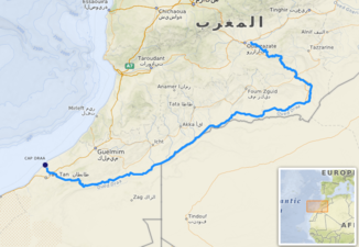
Wadi Draa
|
Wadi Draa Oued Draâ, Wadi Darha, Wadi Dara |
||
| Data | ||
| location | Morocco / Algeria border | |
| River system | Wadi Draa | |
| origin |
El Mansour Eddahbi reservoir near Ouarzazate (Morocco) 30 ° 54 ′ 45 ″ N , 6 ° 45 ′ 36 ″ W |
|
| muzzle | approx. 10 km southwest of Cape Nun , 20 km north of Tan-Tan (southern Morocco) in the Atlantic Ocean Coordinates: 28 ° 40 ′ 56 ″ N , 11 ° 7 ′ 24 ″ W, 28 ° 40 ′ 56 ″ N , 11 ° 7 ′ 24 ″ W.
|
|
| length | 1100 km | |
| Medium-sized cities | Zagora | |
| Small towns | Agdz , Mhamid | |
|
The Oued Draa only carries water after the snow has melted in spring and after heavy rainfall |
||

The Wadi Draa (also Oued Drâa , Darha or Dara ; Arabic وادي درعة, DMG Wādī Darʿa ; Tamazight : ⴷⴻⵔⵄⴰ) is a regularly drying river ( wadi ) in North Africa with a (theoretical) length of about 1100 km. As a river it is only recognizable as far as Zagora ; behind it it dries out for most of the year, although its bed is still noticeable through isolated oases until Mhamid . During the Protectorate Period (1912–1956) in the south, the Draa formed the border with the sparsely populated areas of the Spanish Sahara ; further east it forms the still disputed border with Algeria for about 390 km and is - after rare but sometimes heavy rains - the longest river in Morocco .
geography
The Wadi Draa is formed from the two source rivers Dades and Assif n'Tidili in the west of the High Atlas , which unite at Ouarzazate in the El Mansour Eddahbi reservoir . The river meanders between the High Atlas, the Anti-Atlas and the Djebel Sarhro mountain range in a southeastern direction, past the small town of Agdz and numerous villages such as Tamnougalt . At Zagora, and especially at Mhamid, it only seldom carries water, then continues to flow westwards along the Algerian border at the town of Tagounite , on the other side of the same accompanied by the desert high plateau of the Hammada du Draa , until it flows east-west. Crossing Morocco on average 100 to 150 km north of the border with Western Sahara as a stone river flows into the Atlantic Ocean .
The river Lixos , mentioned in the periplus of the Carthaginian admiral Hanno , is in all probability identical with the Wadi Draa.
prehistory
Rock carvings and petroglyphs have been found from all important periods of prehistory, and Wadi Draa has obviously been visited for many thousands of years. The famous but controversial Venus de Tan-Tan was also found in this wadi - it is estimated by some to be between 300,000 and 500,000 years old. Foum Chenna (Tinzouline), Aït Ouaazik (Asguine Tarna, Tazzarine) Tiouririne and Tisguinine near Zagora are the most famous sites in the Draa region.
Various petroglyphs depicting animals (elephants, rhinos, ostriches, etc.) were also discovered in the Draa Valley. Their age should be between 4000 and 6000 years and come from a time when these animals were still hunted by humans ( hunters and gatherers ). Later, nomadism dominated, which gradually passed into sedentarism.
The oases of the Draa Valley and other oasis valleys in Morocco virtually challenged the settling down of the people passing here, because oases offer everything that is necessary for permanent and sustainable survival. Only grazing animals (sheep, goats) had to be largely banned from the oases, or at least locked up, which led to frequent conflicts and armed clashes with nomadic ranchers. When this process of settling down in the Draa Valley began - which was definitely going to last for centuries - some researchers suspect around 3000 BC. BC, others postulate earlier, still others advocate later dates.
The engravings on some steles and rock slabs, which are covered with previously illegible geometric characters in the so-called "Libyan-Berber script", date from a much later period (around 500 BC to around 500 AD).
Tighremts and Ksour
The traditional house architecture ( Tighremt ) of the Draa Valley has possibly remained unchanged for well over a thousand years, with walls made of rammed earth, ceilings and stairs made of palm trunks and brushwood with covers made of woven palm fronds or reeds - all materials that occur locally and can be obtained inexpensively are. Towers and gates were provided with ornaments, which originally probably had a disaster-warding ( apotropaic ) meaning. Several villages ( Ksour ) of the Draa Valley were surrounded with rammed earth walls to better protect the inhabitants.
Since the 1960s and 1970s, the stone architecture with hollow blocks for the walls and concrete for the ceilings and stairs, which has meanwhile become common practice in the Berber regions of Morocco, has also prevailed in the villages of the Draa Valley . After completion of the shell, the outer walls are plastered and then painted in light red tones.
See also
literature
- Paul G. Bahn: The Cambridge illustrated history of prehistoric art. Cambridge University Press, Cambridge 1998, ISBN 978-0-52145-473-5
- J. Clottes: World Rock Art. The Getty Publications, Los Angeles 2002, ISBN 978-0-89236-682-8
- Werner Huss : The Carthaginians . Beck Verlag, Munich 1990, p. 40, ISBN 3-406-39825-1 .
- Alfred Pletsch: Structural changes in the Dra oasis. Studies on economic and population development in the oasis area of southern Morocco. (Marburger Geographische Schriften, booklet 46) Geographical Institute of the University of Marburg , Marburg 1971
- Werner Pichler: Origin and development of the Libyco-Berber Script. R. Köppe Verlag, Cologne 2007, ISBN 978-3-89645-394-5 .


