Amtoudi
| Amtoudi أمطضي ⴰⵎⵟⴹⵉ |
||||
|---|---|---|---|---|
|
||||
| Basic data | ||||
| State : |
|
|||
| Region : | Guelmim-Oued Noun | |||
| Province : | Guelmim | |||
| Coordinates | 29 ° 15 ′ N , 9 ° 11 ′ W | |||
| Residents : | 1,000 | |||
| Height : | 870 m | |||
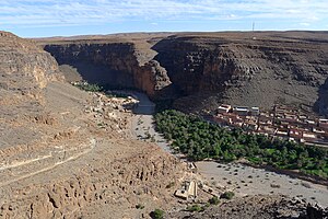
| View from Agadir Id Aissa to Amtoudi (2013) | ||||
Amtoudi or Ametdi (sometimes also called Id Aïssa ; Zentralatlas-Tamazight ⴰⵎⵟⴹⵉ Amṭḍi ) is a small unreinforced Berber village ( douar ) with around 1,000 or a rural community ( commune rurale ) with almost 2,000 inhabitants in the south-western Anti-Atlas in the province of Guelmim in the region Guelmim-Oued Noun in Morocco .
location
Amtoudi is located about 235 km (driving distance) southeast of the city of Agadir or a good 36 km northeast of the town of Taghjijt in a canyon-like river valley of the southwestern foothills of the Anti-Atlas Mountains at an altitude of about 800 to 950 m . Amtoudi can be reached from Agadir on the national road N1, from Bouizakarne then in an easterly direction via the N12 and east from Taghjijt via an asphalted spur road leading in a northeastern direction.
Population and economy
The population consists almost entirely of members of the Berber tribe of the Id Aïssa . The local residents who did not migrate to the cities of the north live - largely according to the principles of self-sufficiency - from the yields of the small, agriculturally usable plots on which barley, wheat and vegetables are grown. The remaining cattle (sheep, goats, chickens) must be kept in stables or pens; During the day it is grazed by the children around 10 to 15 years old.
history
Amtoudi has never been mentioned in Moroccan history. But the place must have played an important role for the local population, because two of the most impressive agadirs (storage castles) in Morocco are only about one kilometer away from the town center . Both are in a grandiose position on high rock ledges, through which they are protected from attacks on three sides.
Agadire
Due to their adaptation to the shape of the terrain, the two Agadirs of Amtoudi - as well as the Agadir Tasguent - are among the few buildings of this type with curved or rounded outer walls.
Agadir Id Aïssa
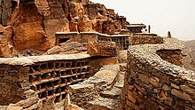
The Agadir Id Aïssa - a "Hofagadir" which is unusual in this region and whose age is estimated to be around 800 years - is the larger of the two and offers completely different views depending on the perspective: The access side is fortified like a castle; the valley side is broad and flanked by two low corner towers, which blend in harmoniously with the surrounding rocky landscape. A wall ring assembled from larger and smaller stone slabs without the use of mortar, in which various storage chambers of different sizes are embedded, encompasses the mountain peak and a rocky area of approx. 2500 m². In the event of attacks by other tribes or migrating cattle nomads , the village population and their cattle could find shelter here for a few days. There was enough food, because various food items (barley, almonds, oil, dates, dried figs, etc.) were stored in the storage chambers; Rainwater was collected and stored in cisterns . Three cell structures made up of small stone slabs were used to accommodate beehives .
Agadir Agellouy
The Agadir Agellouy is a largely covered "cell agadir" with an approximate age of 500 years and hovers on a ledge high above the mostly dried up river valley. Inside there are various storage chambers - arranged on several levels - which can be reached via stepping stones embedded in the masonry .
irrigation
Along the mostly dry river, which can, however, flood parts of the place after heavy or prolonged rainfall, runs a small - nowadays concreted - irrigation canal, which is fed by natural water basins ( gueltas ) located further above and surrounded by rocks . This irrigation canal ensured the water supply for the villagers as well as the irrigation of the fields and a small date palm grove for centuries .
Rock art
There are several petroglyphs, some of which are very old, in the vicinity of the village . Perhaps the oldest (approx. 5000 years) show giraffes , antelopes and other hard-to-identify wild animals that must have lived in the area back then and were hunted and ultimately exterminated by roaming hunters and gatherers , and later also by nomads. One of the rock carvings shows a rather realistic elephant , as it was still found in some areas of the Maghreb in the Punic - Roman times .
See also
- Agadir Guimst
- Agadir Imi'm Korn
- Agadir Itourhaine
- Agadir Inoumar
- Imchiguegueln
- Igherm
- Igherm n'Ougdal
- Timit
- Ibakliwin
literature
- Herbert Popp, Mohamed Ait Hamza, Brahim El Fasskaoui: Les agadirs de l'Anti-Atlas occidental. Atlas illustré d'un patrimoine culturel du Sud marocain. Natural Science Society, Bayreuth 2011, ISBN 978-3-939146-07-0 .
- Salima Naji: Les greniers collectifs de l'Atlas. Patrimoines du Sud Marocain . Paris 2006, ISBN 978-2-7449-0645-9 .
Web links
- Agadire - Storage castles - Igoudars
- Amtoudi. The peak and the agadir. LookLex (English)
- Amtoudi - photo video
- Agadire von Amtoudi and others - photos
- Agadires of Amtoudi, Imchiguegueln, Inoumar and Tasguent - photos


