Tizi n'Test
| Tizi n'Test | |||
|---|---|---|---|
|
|
|||
| Compass direction | Northeast | southwest | |
| Pass height | 2093 m | ||
| region | Taroudannt , Souss-Massa , Morocco | ||
| Valley locations | Marrakech | Taroudant | |
| Mountains | High Atlas | ||
| profile | |||
| Ø pitch | 1.2% (1643 m / 134 km) | 2.1% (1843 m / 89 km) | |
| map | |||
|
|
|||
| Coordinates | 30 ° 52 '5 " N , 8 ° 22' 45" W | ||
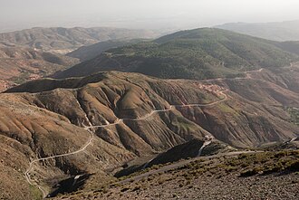
The Tizi n'Test is a 2093 m high mountain pass in the High Atlas in Morocco .
location
The Tizi n'Test pass is located in the province of Taroudannt in the Souss-Massa region and forms the highest point of the connecting road R203 between Marrakech (altitude approx. 450 m ) and Taroudannt (altitude approx. 250 m ). The road is not very important in terms of traffic and is always only poorly repaired. Trucks and buses run comparatively rarely.
Navigability
The single-lane and very winding route leads through scenic areas that have hardly been developed for tourism. Rock falls are to be expected, especially in summer; in the winter months (November to March) the road is partially or fully closed after heavy or prolonged snowfall. Since the daytime temperatures almost always reach plus degrees during the day, even at altitudes of over 2000 m in southern Morocco, the locks are usually lifted after a few hours, but in rare cases only after days. The section from the N10 to the top of the pass has short uphill and downhill sections of 10% and more.
Infrastructure
At the few stopping bays there are small souvenir stands (rock crystals, fossils, ceramics, Berber jewelry, etc.); Tea or coffee is only available in the rest stops along the road (e.g. Ijoukak ). There are hardly any villages from the top of the Tizi n'Test to Taroudannt.
history
The route was already known to the Berber tribes of earlier centuries, who grazed their cattle (sheep, goats) on the rocky but grassy mountain slopes in summer. In the late 19th and early 20th centuries, the pass was controlled by the Goundafa Berber tribe . During the French colonial rule , the old trade route was expanded into a runway between 1926 and 1932; in the 1960s the route was paved for the first time.
places
The following places are close to the R203:

