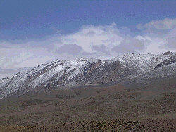
Jbel M'Goun
| Jbel M'Goun | ||
|---|---|---|
|
Jbel M'Goun from the North (Tarkeddit) |
||
| height | 4068 m | |
| location | Ouarzazate , Drâa-Tafilalet , Morocco | |
| Mountains | High Atlas | |
| Notch height | 1974 m | |
| Coordinates | 31 ° 30 '36 " N , 6 ° 26' 24" W | |
|
|
||
| particularities | Third highest mountain in North Africa | |
The Jbel M'Goun (also Ighil M'Goun , more rarely Ighil n'Oumsoud ; Central Atlas Tamazight ⵉⵖⵉⵍ ⵎⴳⵯⵏ ) is 4068 m after the Jbel Toubkal ( 4167 m ) and its neighboring summit, the Jbel Ouanoukrim ( 4089 m ) third highest mountain in Morocco and North Africa . The M'Goun massif has no prominent or dominant summit , but an almost 10 km long chain of peaks ( crête ), the altitude of which always fluctuates around 3500 to 4000 m.
location
Jbel M'Goun is located about 20 km south of the village of Agouti in the Aït Bougoumez valley . The summit is already in the province of Ouarzazate . Jbel Toubkal is about 100 km (as the crow flies) to the west. The Assif M'Goun rises on its eastern flank and flows into the Oued Dades at El-Kelâa M'Gouna , which in turn forms the Oued Drâa at Ouarzazate together with other small tributaries .
geology
The mountain range of the M'Goun, which runs in a west-east direction, is formed by an anticlinal saddle made of hard limestone, which was formed during the geological unfolding of the High Atlas. During the ice ages of the Quaternary several developed glacial valleys in north-south direction.
climate
Precipitation in the form of snow only falls in the winter months (October to February); summer rains are extremely rare. From around April the daytime temperatures on the south side of the mountain normally reach around 20 ° C during the day, so that the last winter snowfields melt away. On the north side they remain a little longer, but they also disappear in July at the latest.
Ascent
An ascent of Jbel M'Goun, which is also possible for inexperienced tourists in the summer months (May to September), usually takes place as part of a two or three-day north-south traverse from Agouti in the Aït Bougoumez valley, which is around 1800 m high, and ends mostly in the village of Amezri in the province of Ouarzazate . A winter ascent is also possible and is considered a bit easier than that of the Toubkal.
See also
literature
- Hamish Brown: The High Atlas. Treks and climbs on Morocco's biggest and best mountains. Cicerone, Milnthorpe 2012, ISBN 978-1-85284-671-8 , p. 57 ff.
Web links
- Hochweide and Jbel M'Goun - photo
- Jbel M'Goun mountain range - photo
- View from the Oasis of Skoura to the M'Goun chain - photo
- Crumbling Kasbah at El Kelâa M'Gouna - photo
Remarks
- ↑ The altitude information differs slightly depending on the source.

