Ait Ourir
| Aït Ourir آيت ورير ⴰⵢⵜ ⵓⵔⵉⵔ |
||||
|---|---|---|---|---|
|
||||
| Basic data | ||||
| State : |
|
|||
| Region : | Marrakech-Safi | |||
| Province : | Al Haouz | |||
| Coordinates | 31 ° 34 ′ N , 7 ° 40 ′ W | |||
| Residents : | 39,108 (2014) | |||
| Area : | 15 km² | |||
| Population density : | 2,607 inhabitants per km² | |||
| Height : | 670 m | |||
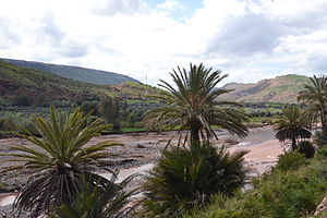
| Landscape near Aït Ourir with Oued Zat | ||||
Aït Ourir ( Arabic آيت ورير, Zentralatlas-Tamazight ⴰⵢⵜ ⵓⵔⵉⵔ ) is a city with about 50,000 inhabitants at the foot of the High Atlas in the province of Al Haouz in the Marrakech-Safi region , Morocco .
Location and climate
The city of Aït Ourir is located on a busy road (RN9) over the High Atlas approx. 33 km (driving distance) southeast of Marrakech on the Oued Zat at an altitude of approx. 670 m ; the further course of the road leads over the 2260 m high Tizi n'Tichka pass and the mountain villages of Aguelmous , Igherm n'Ougdal and past Aït Benhaddou to Ouarzazate . The climate is temperate to warm; Rain (approx. 570 mm / year) falls almost exclusively in the winter half-year.
Population development
| year | 1994 | 2004 | 2014 |
| Residents | 12,162 | 20.005 | 39,108 |
The inhabitants of the municipality are almost without exception Berbers ; many have immigrated from the surrounding mountain villages.
economy
The traditional economy is concentrated in the fields on the riverside; barley is mainly grown here. It is usually too cold to grow vegetables (there can still be night frosts in summer) and so they have to be bought or exchanged at the markets. Mainly cattle breeding and grazing (sheep and goats) are practiced. Apple trees are also widespread. For most tourists, Aït Ourir is just a transit point on their way to Aït Benhaddou and Ouarzazate. Aït Ourir is popular among amateur geologists because of the numerous mineral finds in the area.
history
As in most of Morocco's Berber regions, there are no written records of the site's history. However, it can be assumed that the place was discovered by semi-nomads from the lower regions of the country on their summer hikes with the herds of cattle in the mountain regions and that at some point later it was permanently settled.
Attractions
The place has completely changed its appearance since the 1960s - the old single-storey houses, built of stone and clay and covered with flat reed or thatched roofs, have largely been replaced by two-storey new buildings made of concrete (foundation and ceilings) and hollow block bricks (walls) all of which were plastered and painted in reddish tones. The vegetable and cattle market ( suq ) is well worth seeing .


