Ourika (river)
|
Oued Ourika نهر أوريكا |
||
|
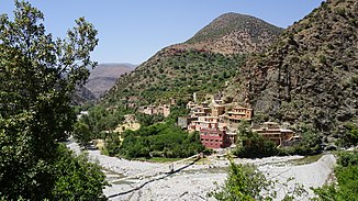
Oued Ourika in the High Atlas |
||
| Data | ||
| location | SW Morocco | |
| River system | Tensift | |
| Drain over | Tensift → Atlantic | |
| source | in the High Atlas 31 ° 11 ′ 38 ″ N , 7 ° 40 ′ 10 ″ W. |
|
| Source height | approx. 2500 m | |
| muzzle | approx. 20 km northeast of Marrakech in the Oued Tensift Coordinates: 31 ° 41 '27 " N , 7 ° 47' 45" W 31 ° 41 '27 " N , 7 ° 47' 45" W |
|
| Mouth height | approx. 500 m approx. | |
| Height difference | approx. 2000 m | |
| Bottom slope | approx. 20 ‰ | |
| length | 100 km | |
| Catchment area | 1500 km² | |
| Communities | Anemiter, Setti Fatma | |
|
Oued Ourika in the Ourika Valley |
||
The 100 km long Oued Ourika ( Arabic نهر أوريكا) Is a major river in the region Marrakech-Safi in southern Morocco .
geography
The Oued Ourika rises in the High Atlas at a height that changes with the seasons on the northern flank of the 4167 m high Jbel Toubkal, approx. 30 km (as the crow flies) southwest of the mountain village of Setti Fatma . It flows first in northeastern, later in northern directions and finally flows into the Oued Tensift about 20 km northeast of Marrakech .
function
The Oued Ourika is primarily used to irrigate the crops along its banks. Since the laying of plastic pipes around the turn of the millennium, the water supply for the residents no longer plays a role; sometimes cattle are still watered.
Places on the river
- Anemiter
- Setti Fatma
Attractions
The mountain landscape on the upper reaches of the Oued Ourika offers many attractive aspects. Mountain hikes or multi-day trekking tours are possible; Canoe tours are also offered. On the middle reaches the archaeological site of the abandoned city of Aghmat is worth mentioning.
Web links
- Oued Zat - short information (English)

