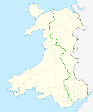
A470 road
| A470 road in the UK | |
| map | |
| Basic data | |
| Operator: | Welsh Government |
| Start of the street: |
Cardiff ( 51 ° 29 ′ N , 3 ° 11 ′ W ) |
| End of street: |
Llandudno ( 53 ° 19 ′ N , 3 ° 49 ′ W ) |
| Overall length: | 299 km (185.8 mi ) |
The A470 is a British state road from Cardiff to Llandudno . It crosses Wales in a north-south direction with a length of 299 km, making it the most important road in this direction.
Common alignment with higher quality roads
- At Brecon together with the A40 (from 51 ° 56 ′ 43 ″ N, 3 ° 24 ′ 37 ″ W to 51 ° 56 ′ 26 ″ N, 3 ° 21 ′ 34 ″ W )
- Between Rhayader ( 52 ° 18 ′ 1 ″ N, 3 ° 30 ′ 38 ″ W ) and the Roundabout southeast of Llangurig ( 52 ° 24 ′ 14 ″ N, 3 ° 36 ′ 4 ″ W ) together with the A44
