Acanuno
| Acanuno | ||
|---|---|---|
|
|
||
| Coordinates | 8 ° 33 ′ S , 125 ° 39 ′ E | |

|
||
| Basic data | ||
| Country | East Timor | |
| Dili | ||
| Administrative office | Cristo Rei | |
| ISO 3166-2 | TL-DI | |
| Suco | Hera | |
| height | 179 m | |
| Residents | - | |
| Metropolitan area | 281 (2000) | |
|
Government Buildings in Acanuno
|
||
Acanuno ( Acanunu , Akanunu ) is a place in the East Timorese Suco Hera ( administrative office Cristo Rei , municipality Dili ). Acanuno forms an Aldeia Heras. In January 2015 there were around 2,562 residents in the Aldeia.
geography
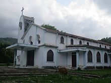
Acanuno is located in the center of Sucos in the Cristo Reis mountains. The northern coastal road leads past the village, which leads inland a little here and is one of the most important traffic routes in the country. To the west lies the state capital Dili , to the east Hera , the administrative seat of Sucos. Acanuno has a church and a primary school.
Web links
Commons : Acanuno - collection of images, videos and audio files
Individual evidence
- ↑ Direcção-Geral de Estatística : Results of the 2015 census , accessed on November 23, 2016.
- ^ Timor-Leste GIS-Portal ( Memento from June 30, 2007 in the Internet Archive )
- ↑ UNMIT: Timor-Leste District Atlas version 02, August 2008 ( Memento from December 3, 2011 in the Internet Archive ) (PDF; 448 kB)


