Acquafraggia
| Acquafraggia | ||
|
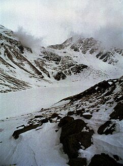
Acquafraggia lake in March 2007 |
||
| Data | ||
| location | Sondrio Province , Lombardy , Italy | |
| River system | Po | |
| Drain over | Mera → Adda → Po → Adria | |
| source | on the southern slope of the Cima di Lago | |
| muzzle | in the Mera coordinates: 46 ° 19 ′ 31 ″ N , 9 ° 25 ′ 54 ″ E 46 ° 19 ′ 31 ″ N , 9 ° 25 ′ 54 ″ E
|
|
|
The waterfall at Borgonuovo |
||
The Acquafraggia (also Acqua Fraggia ) is a mountain stream in the province of Sondrio in Lombardy , in northern Italy.
course
![]() Map with all coordinates of the section History : OSM
Map with all coordinates of the section History : OSM
Its source lies on the southern flank of the Cima di Lago (also Cima da Lägh ), on the northern side of the Val Bregaglia and near the Swiss border. From here it flows in a south-south-west direction within the territory of the municipality of Piuro .
In the mountain lake Lago dell'Acqua Fraggia at an altitude of 2043 m, a further 13 tributaries from mountain streams on the southern slope of the Cima di Lago are received. (Location: 46 ° 21 ′ 45 ″ N, 9 ° 27 ′ 34 ″ E ) The area of the tributaries of the lake extends from northwest to northeast to east. The outflow of the lake is in the southwest.
Between the Lago dell'Acqua Fraggia and Savogno the river is directed to the south or south-southwest and has 7 right and 6 left inflows.
In Savogno, a historic sawmill was operated by water power. (Location: 46 ° 20 ′ 18 ″ N, 9 ° 26 ′ 39 ″ E )
To the north and above the village of Borgonuovo , the divided river plunges over two spectacular waterfalls to the valley. (Location: 46 ° 19 ′ 53 ″ N, 9 ° 26 ′ 13 ″ E ) Within Borgonuovo, the Acquafraggia takes on a left and then a right tributary before it flows into the Mera . (Location: 46 ° 19 ′ 31 ″ N, 9 ° 25 ′ 54 ″ E )

