Adam's Peak
| Adam's Peak | ||
|---|---|---|
| height | 2243 m | |
| location | Ratnapura District , Sri Lanka | |
| Coordinates | 6 ° 48 ′ 30 ″ N , 80 ° 30 ′ 0 ″ E | |
|
|
||
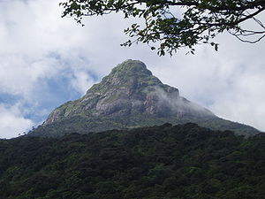
The Adam's Peak [ ædəmz PIK ] ( Sinhala : සමනළ කන්ද Samanala Kanda [ samənələ ˌkan̪d̪ə ] "butterfly mountain", Tamil : சிவனொளிபாத மலை Civaṉoḷipāta Malai [ siʋənoɭiˌpaːd̪ə ˌmalɛi̯ ]) is a 2,243 meters high mountain in the central highlands of Sri Lanka . It is located in the district of Ratnapura in the province of Sabaragamuwa . Of Adam's Peak is known for the Sri Pada (Sinhala: ශ්රී පාදය Lord Padaya [ ˌɕriː paːd̪əjə ], from the Sanskrit for "holy foot"), a recess in a rock near its summit, as footprint of the one Buddha , of others as that of the god Shiva or, in turn, by others as that of Adam . Because of its religious significance, Adam's Peak is the most famous, if not the highest mountain in Sri Lanka (this is the Pidurutalagala ).
Religious meaning
The mountain is a pilgrimage site for Buddhists , Hindus , Muslims and Christians .
On the summit there is an inhabited monastery , in which there is a 1.8 meter long footprint (“Sri Pada”), which Buddhists venerate as the Buddha's footprint . Hindus consider the footprint to be that of Shiva . Muslims see it as the footprint of Adam , Christians that of the Apostle Thomas .
According to Sinhala Buddhist belief, every good Buddhist should have climbed this mountain at least once in a lifetime.
The climb

The pilgrimage season begins with the December full moon and ends with the last full moon in May.
Traditionally, the mountain is climbed at night . So you can avoid the heat of the day and watch the sunrise, which is accompanied by the locals with euphoric "Sadhu, Sadhu" calls, and look at the triangular shadow of the mountain in the mist on the western side.
There are two main routes possible for the ascent:
- from the north from Nallathanniya (Dalhousie) directly at the foot of the mountain. The ascent of about 1000 meters takes a few hours. Nallathanniya is southwest of Hatton train station .
- from the south from Ratnapura longer route via Malawa – Palabadalla – Heramitipana. Hike of around 7 to 8 hours.
The seven-kilometer northern ascent, which consists of long stretches of steep steps and via ferratas and takes six hours at a leisurely pace, is lined with numerous tea rooms and has been electrically lit at night during the pilgrimage season since the late 1980s. From earlier centuries there are reports of how pilgrims died of exhaustion due to the exertions of the ascent or were blown into the abyss by gusts of wind from the path that was not yet secured with railings; even today there are regular deaths.
tourism
In Dalhousie, the starting point of the ascent from the north, which is easily accessible from Hatton by bus and taxi, there are numerous inns and shops that offer accommodation, souvenirs and food. From the top of the mountain there is a wonderful view of a panorama with a view of the "Hill Country" in the north and east and down to the plains in the south and west; on a clear day you can see as far as Colombo (approx. 65 km). The nearest train station is in Hatton on the Colombo – Badulla railway line , the nearest major city is Nuwara Eliya .
literature
- S. Paranavitana: The God of Adam's Peak. In: Artibus Asiae. Supplementum, Vol. 18, 1958, pp. 1-78
Web links
- Sri Pada or Adam's Peak: Lanka's Holy Mountain. sripada.org (English)


