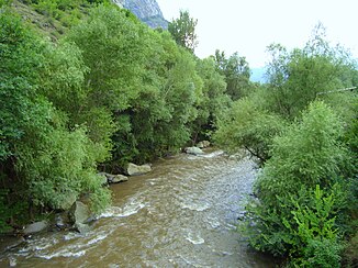
Aghstafa (river)
|
Aghstafa Agstafa, Aghstew |
||
| Data | ||
| location | Armenia , Azerbaijan | |
| River system | Kura | |
| Drain over | Kura → Caspian Sea | |
| origin |
Pambak Mountains 40 ° 46 ′ 39 ″ N , 44 ° 39 ′ 51 ″ E |
|
| muzzle |
Kura coordinates: 41 ° 14 ′ 30 " N , 45 ° 26 ′ 24" E 41 ° 14 ′ 30 " N , 45 ° 26 ′ 24" E
|
|
| length | 121 km | |
| Catchment area | 2500 km² | |
| Drain |
MQ |
8.22 m³ / s |
| Right tributaries | Getik | |
| Medium-sized cities | Ijevan , Qazax | |
| Small towns | Dilijan | |
|
Catchment area (in yellow) and course of the Aghstafa river in Armenia |
||
The Aghstafa (also Ağstafa or Aghstew ; Armenian Աղստև ; Azerbaijani Ağstafaçay ) is a right tributary of the Kura in Armenia and Azerbaijan .
The Aghstafa rises in the Pambak Mountains in Armenia. It initially flows in an easterly direction. It flows past the city of Dilijan . Later she turns north-northeast, passes the city of Ijevan and crosses the border into Azerbaijan. There it flows through the city of Qazax and finally flows into the Kura. The river is dammed above Qazax. Some of the river water is diverted for irrigation purposes .
The Aghstafa has a length of 121 km. It drains an area of 2500 km². The mean discharge is 8.22 m³ / s.
Web links
Commons : Aghstafa - collection of images, videos and audio files

