Ajagös (river)
|
Ajagös Kazakh Аягөз |
||
|
|
||
| Data | ||
| location | East Kazakhstan ( Kazakhstan ) | |
| River system | Ajagös | |
| source | in the Tarbagatai mountains 47 ° 39 ′ 31 ″ N , 81 ° 22 ′ 44 ″ E |
|
| muzzle |
Lake Balkhash coordinates: 46 ° 39 ′ 46 ″ N , 79 ° 14 ′ 14 ″ E 46 ° 39 ′ 46 ″ N , 79 ° 14 ′ 14 ″ E |
|
| Mouth height |
342 m
|
|
| length | 492 km | |
| Catchment area | 15,700 km² | |
| Medium-sized cities | Ajagös | |
|
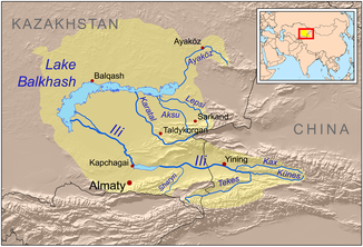
Course of the Ajagös (English Ayaköz) in the catchment area of Lake Balkhash |
||
The Ajagös ( Kazakh Аягөз , Russian Аягоз ) is a tributary of Lake Balkhash in eastern Kazakhstan .
The Ajagös rises on the northern flank of the Tarbagatai Mountains . It flows first in a north-westerly direction, passes the city of the same name, Ajagös , then turns south and flows through a semi-desert-like landscape. During floods , it reaches the eastern end of Lake Balkhash south of Aqtogai . The Ajagös is mainly fed by the snowmelt . Part of the river water is used for irrigation .
