Albertstrasse (Berlin)
| Albertstrasse | |
|---|---|
| Street in Berlin | |
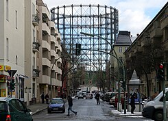
| Albertstrasse with the Schöneberg gasometer |
|
| Basic data | |
| place | Berlin |
| District | Schöneberg |
| Created | 1886/1887 |
| Hist. Names | Street 63 |
| Connecting roads |
Eisenacher Strasse (west) , Ebersstrasse (east) |
| Cross streets | Fiery Road |
| use | |
| User groups | Pedestrian traffic , bicycle traffic , car traffic |
| Technical specifications | |
| Street length | 250 meters |
The Albertstraße in Berlin district Schoneberg ( Tempelhof-Schöneberg ) is almost 250 meters long and provides a connection between the main road and the Ebersstrasse is. In this case it crosses the Feurigstraße . The postcode is 10827. Along the road you have a view of the Schöneberg Gasometer in a south-easterly direction , which is the landmark of the “ Red Island ” as a landmark visible from afar .
location
For the most part, the street crosses a purely residential area. Only a few businesses and a corner pub can be found on the ground floors of the multi-storey residential buildings. The villa built by W. Bröker in 1891/1892 at Albertstraße 12 / corner Feurigstraße 24 - also known as the “Red Villa” - is a listed building . According to contemporary witness Paul Tollmann , the National Socialists conducted numerous interrogations and mistreatment of political opponents in the building in 1933.
Origin of name
The street was led after its layout in 1886/1887 as street 63 and got its current name in 1888 after the first name of the Schöneberg city councilor and mayor Albert Grix (1838–1913), a master blacksmith who lived next to the town of Schöneberg , which was independent until 1920, and part of his property left free to build the road.
Web links
- Albertstrasse. In: Street name lexicon of the Luisenstädtischer Bildungsverein (near Kaupert )
Individual evidence
- ^ Karl Grünberg: Stay or go ... In: Der Tagesspiegel , March 3, 2013
Coordinates: 52 ° 29 ′ 2 ″ N , 13 ° 21 ′ 14 ″ E
