Alderley Edge
| Alderley Edge | ||
|---|---|---|
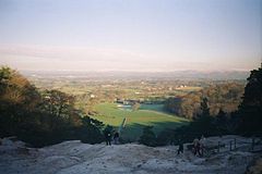
| View from Stormy Point | ||
| Coordinates | 53 ° 18 ′ N , 2 ° 14 ′ W | |
| OS National Grid | SJ843785 | |
|
|
||
| Residents | 4408 (status: 2009) | |
| administration | ||
| Post town | ALDERLEY EDGE | |
| ZIP code section | SK9 | |
| prefix | 01625 | |
| Part of the country | England | |
| region | North West England | |
| Shire county | Cheshire | |
| Website: www.cheshireeast.gov.uk | ||
Alderley Edge is a Civil parish in Cheshire about 19 km south of Manchester . The community has 4409 inhabitants (as of 2001).
history
In 1995, 564 Roman coins from the period between 317 and 338 were found here. In the 13th century, the place name Chorlegh (later: Chorley) is first mentioned north of Nether Alderley . Copper was mined in the region during the Bronze Age and from the late 17th century to the early 20th century.
In 1880, the baptized Manchester and Birmingham Railway to avoid the lying north of Manchester Chorley train station Alderley Edge Railway Station . "Edge" refers to a Triassic sandstone formation .
Personalities
Born in Alderley Edge
- John Norman Collie (1859–1942), chemist, mountaineer and explorer
- Rushton Coulborn (1901–1968), historian
Alderley Edge was and is a popular place to live at the gates of Manchester , e.g. B. for:
- David Beckham (* 1975), soccer player (resident until 2003)
- Victoria Beckham (* 1974), singer (resident until 2003)
- Alan Garner (born 1934), fantasy author
- Bernard Sumner (born 1956), rock musician
Web links
Commons : Alderley Edge - collection of images, videos and audio files

