
Aleje Jerozolimskie
| Aleje Jerozolimskie | |
|---|---|
|
|
|
 |
|
| Basic data | |
| place | Warsaw |
| District | Skorosze, Salomea, Stare Włochy, Raków, Szczęśliwice, Stara Ochota, Filtry, Śródmieście Południowe, Śródmieście Północne |
| Places | plac Zawiszy |
| Buildings | Poniatowski Bridge |
| Subway stations | Center |
| use | |
| User groups | Pedestrian traffic , public transport , car traffic |
| Technical specifications | |
| Street length | 10 km |
The Jerozolimskie Avenue (German: Jerusalem Avenue ) is one of the main streets of Warsaw . It begins on the edge of the Warsaw Vistula embankment . Before the Second World War it ended at Artur-Zawisza-Platz. In the 1960s it was extended to the suburb of Pruszków , which meant an increase in length from the original 2.7 to almost 16 kilometers.
The name of the street is reminiscent of a Jewish settlement that was built in the 18th century outside the Warsaw metropolitan area in the area around today's Zawisza Square. The road was marked out in 1824-1825.
Tracks of long-distance rail traffic running through Warsaw's inner city run along the “old” Jerusalemer Alleen - first (from east to west) in two tunnels for suburban and long-distance traffic, then under the central station , further under a reinforced concrete slab and even further in an open one Excavation. The first tunnel was built between 1921 and 1932, the second in the post-war period.
On the "old" section there are intersections with Nowy Świat Street , Krucza Street, Marszałkowska Street , Emilii Plater Street, Johannes Paul II Avenue, Żelazna Street and Artur Street. Zawisza Square. The "new" section was built on the former railway site and runs through Warsaw suburbs. Many road crossings were built on two levels on this section, connecting the road with the new arterial roads to the A2 motorway.
The intersection with Marszałkowska Street ( Rondo Romana Dmowskiego ) is considered the center of Warsaw.
Right at the beginning is the National Museum and the Banking and Finance Center , which was the seat of the Central Committee of the Polish United Workers' Party until 1990 . The intersection with Nowy-Świat-Straße was designed as a round square, named after General Charles de Gaulle . In the middle is an artificial palm . In front of the intersection with Krucza Street is the Smyk department store , which was built in the early 1950s and retained the modern, western look despite the then obligatory style of Socialist Realism .
At the intersection with Marszałkowska Street is the entrance to the subway and the round PKO building in Warsaw , which was almost completely destroyed by a gas explosion on February 15, 1979.
On the next section of the street there are two pavilions that form the entrance to the underground suburban train station Warszawa Śródmieście . In the years 1952–1955 the Soviet government built a high-rise - the Palace of Culture and Science . Numerous apartment buildings from the beginning of the 20th century have been preserved across the street.
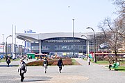
The central train station is located between Emilia-Plater-Strasse and Johannes-Paul-II-Allee. It was built in the early 1970s and was thoroughly renovated in 2010-2011. On the opposite side of the street is the Mariott Hotel , built by a Swedish company before the turn of the 1990s.
On the next section of the road, the railway tracks run under a reinforced concrete ceiling, partly built on by a low office and commercial building, the remaining area serves as a parking lot.
The railway tracks are laid in the open excavation between Żelazna Street and Zawisza Square. On the opposite side, a Turkish company built a high-rise building in the late 1990s (originally: “Reform Plaza”, today “ Millennium Plaza ”), which the Warsaw people mocked as toi-toi or “shower cubicle” because of its shape and color .
After Zawisza Square, the new section of road begins, which extends to Pruszków. Because of the complicated shape of Zawisza Square, traffic was diverted to the east through the Ochota district . This section leads past the Westbahnhof ( Dworzec Zachodni ). Numerous new buildings have been built along the street since the 1970s.
Traffic from Jerusalemer Allee is directed eastward through 3-Mai-Allee and further through Poniatowski Bridge and Aleja Waszyngtona ( Washington-Allee ). 3-Mai-Allee was built on a reinforced concrete viaduct from the beginning of the 20th century.
Web links
- Aleje Jerozolimskie in Warszawikia (Polish)

National Museum

Charles de Gaulle Square

Dmowski Square

Rebuilt tenement house
Central Station

Orco skyscraper

Millenium Plaza skyscraper

Sobieski Hotel on Artur Zawisza Square


