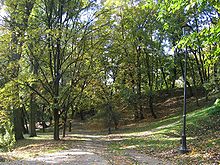
Warsaw Vistula embankment


The Warsaw Vistula embankment (Polish: Skarpa Warszawska ) is the name given to the natural western edge of the east-west running glacial valley of the Vistula in the Warsaw city area, which played an important role in the development of Warsaw and also influences today's urban development.
topography
The Warsaw Embankment is part of the Vistula Embankment (Polish: Skarpa Wiślana ), which extends over a great distance and runs through the country near the west bank of the Vistula from south to north. It was formed about 15,000 years ago as a result of the runoff of large amounts of glacial meltwater at the end of the Vistula Ice Age .
Natural canyons
The embankment in the Warsaw area is often broken through by small gorges (Polish: Dolinka ) towards the Vistula valley. These gorges were created by erosion and by runoff from glacier, spring or groundwater. Some of the larger of these canyons are:
- Służewiec Valley - formed by the river of the same name near the former settlement of Służewiec . On the edge of the valley is Fort VIII of the Warsaw Fortress , St. Catherine's Church and the former Gucin Gaj park .
- Żurawka Valley - in which Książęca Street runs eastwards from Plac Trzech Krzyży today . The Warsaw Stock Exchange is about to be broken off.
- Bełcząca Valley (Nalewki) - expanded in the 19th century as part of the construction work on the citadel and the neighboring Fort Władimir .
Artificial breakthroughs
In addition to the natural incisions in the embankment, anthropogenic breakthroughs in the edge also arose during the development of the city . Especially for traffic purposes, the following were created:
- Agrykola -Aushub with a height difference of around 20 meters from the 18th century
- Aleje Jerozolimskie -Aushub with a height difference of around 20 meters from the 19th century
- Excavation on Karowa Street ( Stanisław-Markiewicz Viaduct ) with a height difference of about 10 meters from the 19th century
- Tunneling under the west-east railway connection ( Kolej średnicowa ) with a height difference of around 10 meters
- Tunneling under the Trasa WZ with a height difference of around 10 meters
- Vistula bank road in the Młociny area with a height difference of 15 meters
- Excavation of the Trasa Łazienkowska with a height difference of 20 meters
- Excavation of the Trasa Armii Krajowej with a height difference of 5 meters
Due to construction work and natural erosion, parts of the earth break off at the edge time and again. So that was St. Anne's Church in conditioning of the tunnel for the East-West line extremely vulnerable in the area of the Citadel, development around the Sejm and the increasingly close advancing to the edge of development of the district Ursynów (especially in the Nowoursynowska Street area) repeated problems occurred.
Significance for urban development
The high bank of the Vistula was a major reason for the establishment and growth of Warsaw. The location of the city and residence on the demolition edge had many advantages. The eastward defense was so easy due to the natural steep slope that no significant fortifications had to be built on this side. The air movement made the climate favorable, the soils on the embankment dry; there was no risk of flooding. During the expansion of the city, the embankment played a role as a preferred location for palaces and villas - especially on the upper part of the royal wing - because of its wide view . The rough draft of a regulatory plan for the capital Warsaw, submitted by Tadeusz Tołwiński in 1916, takes into account for the first time the importance of the Vistula embankment in urban development.
Course of the embankment
The embankment runs in the Warsaw area from southeast to northwest and thus follows the course of the Vistula. In the south, at a distance of around two kilometers from the course of today's Vistula from the Kabaty Forest, it forms a natural border between the urban districts of Ursynów (on the embankment) and Wilanów in the valley with its Miasteczko Wilanów district . It limits the campus of the Natural Science University . The slope, which flattens out here, reaches the Dolina Potoku Służewieckiego (street) approximately at the level of the Church of St. Catherine in Służew and then divides the Mokotów district into the old districts of Upper and Lower Mokotów. It passes the Królikarnia Palace , the Morskie Oko Park as well as the Łazienki Park and the Ujazdowski Palace and thus steadily approaches the Vistula. From Ujazdowskie-Alleen, the embankment runs roughly parallel to the Warsaw Royal Route until it reaches the Mariensztat housing estate below and the old and new town with the adjacent citadel above . There it runs in close proximity to the Vistula; the distance here is only around 200 meters. From Żoliborz , the course of the embankment moves away from the river in a westerly direction. Later, the embankment runs through the Las Bielański reserve and approaches the Vistula again at the level of the “Młociński” park.
References and comments
- ↑ according to Short version of a publication ( ISR - gray series , ISBN 978-3-7983-2071-0 , Berlin 2008) for the workshop Mokotow - meeting point of culture and nature at the Technical University of Berlin in 2007
- ↑ according to the message Na Ursynowie osunęła się skarpa. Ewakuowano trzy domy for the evacuation of three residential buildings in Ursynów at Gazeta.pl from June 4, 2010 (in Polish)
- ↑ according to Werner Huber, Warsaw - Phoenix from the ashes. An architectural city guide , Verlag Böhlau, ISBN 3-412-14105-4 , Cologne 2005, p. 31


