Alsterån
| Alsterån | ||
|
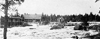
Alsterån near Fröseke in 1925 |
||
| Data | ||
| location | Kronobergs län , Kalmar län ( Sweden ) | |
| River system | Alsterån | |
| origin | See Alstern 56 ° 59 '50 " N , 15 ° 24' 42" O |
|
| Source height | 217 m above sea level | |
| muzzle | at Pataholm in Kalmarsund Coordinates: 56 ° 55 ′ 13 " N , 16 ° 26 ′ 7" E 56 ° 55 ′ 13 " N , 16 ° 26 ′ 7" E |
|
| Mouth height | 0 m o.h. | |
| Height difference | 217 m | |
| Bottom slope | 1.4 ‰ | |
| length | 150 km (including source rivers) | |
| Catchment area | 1,524.8 km² | |
| Drain |
MQ |
10 m³ / s |
| Left tributaries | Badebodaån | |
| Flowing lakes | Store Hindsjön, Allgunnen , Hultsnäsesjön | |
| Communities | Alstermo , Alsterbro , Blomstermåla , Ålem | |
The Alsterån is a river in eastern Småland in southern Sweden . It has its origin in Lake Alstern . From there it flows in an easterly direction past the places Alstermo , Alsterbro , Blomstermåla and Ålem to Kalmarsund , into which it flows at Pataholm . It flows through Lake Allgunnen , into which its largest tributary, the Badebodaån , flows from the north . Including source rivers, the river length is 150 km. The catchment area covers 1524.8 km². The mean discharge at the mouth is 10 m³ / s.
There are anadromous sea trout in the river below the Hornsö hydroelectric power station .
Individual evidence
- ↑ Sveriges Meteorologiska och Hydrologiska Institut (SMHI) - Sjöareal och sjöhöjd (PDF; 3.5 MB)
- ↑ Sveriges Meteorologiska och Hydrologiska Institut (SMHI) - Län och huvudavrinningsområden i Sverige (PDF; 2.5 MB)
