
Altai flood

The Altai flood was a super flood that occurred at the end of the last ice age around 14,000 years ago due to the melting of ice reservoirs in the Altai , Chuja and Kuray basins. Geologists estimate that between 600 and 3,500 cubic kilometers of water leaked out of the glacial lake as a result of an ice dam fracture . The flood is said to have spread across the Black Sea to the Mediterranean .
background

The Altai Mountains are on the border of Russia , Kazakhstan , the People's Republic of China and Mongolia . At the end of the last ice age , large ice reservoirs formed as the earth warmed up. When the ice dams surrounding the ice reservoirs failed, catastrophic flooding occurred. In total, there should have been three mega-floods in the Altai, of which the last was probably the largest. This flooding was caused by two connected lakes and is known as the Altai Flood.
As the depth of the water increased, the pressure at the bottom of the ice dam increased. This dropped the freezing point of the water below the temperature of the ice that formed the dam. The height of the dam on the Altai is estimated at 600 to 900 meters; accordingly the pressure at the foot of the dam was around 60 to 90 bar. This made it possible for liquid water to penetrate cracks in the dam and generate enough heat through friction so that more water could flow in. This feedback effect weakened the ice dam, eventually leading to catastrophic dam failure.
The water drainage around followed the bed of the Katun . The flood lasted about two to three days and reached peaks in water runoff of about 10 to 18 million cubic meters per second and speeds of up to 45 meters per second. The maximum height of the tidal wave was calculated to be 320 meters.
proof

The flood disaster was proven by analyzing surface forms such as ripples and terraces in the Altai region.
In the runoff area of the Altai flood there are large areas with giant ripples . These ripples are around 20 to 24 meters high and have a wavelength of around 200 to 300 meters. The ripples are stretched across the diluvial tides. The proximal slopes are more gently sloping, while the distal slopes are steeper with a slightly concave profile at the ridge. Large, sharp-edged rocks can be found in the sediments. The sharpness of the edges is an important distinguishing feature from boulders transported through glaciers and a feature that suggests a flood disaster. The sediments of the ripples are largely loose and dry and not hardened by filling material.
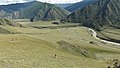
Katun photographed from a giant ripple
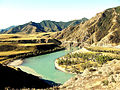
Terracing at Katun

Huge ripples on the Katun


literature
- Devon M. Burr, Paul A. Carling, Victor R. Baker: Megaflooding on Earth and Mars , Cambridge University Press, 2009, ISBN 978-0-521-86852-5
Web links
Individual evidence
- ↑ Paul Carling , Ignacio Villanueva, Jürgen Herget , Nigel Wright, Pavel Borodavko, Hervé Morvan: Unsteady 1D and 2D hydraulic models with ice dam break for Quaternary megaflood, Altai Mountains, southern Siberia , In: JC Woodward, PA Brewer, MG Macklin, S. Tooth: Advances in Palaeoflood Science. Global and Planetary Change. , 70, 1-4, pp. 24-34 (February 2010).
- ↑ a b Altai Flood
- ↑ Alexei N. Rudoy : Glacier-dammed lakes and geological work of glacial superfloods in the Late Pleistocene, Southern Siberia, Altai Mountains . In: Quaternary International , 87, 2002, pp. 119-140
- ^ Jürgen Herget: Reconstruction of Ice-Dammed Lake Outburst Floods in the Altai Mountains, Siberia - A Review . In: Jour. Geol. Soc. India , 64, 2004, pp. 561-574
- ↑ Victor R. Baker : Overview of megaflooding: Earth and Mars , in: Devon M. Burr, Paul A. Carling, Victor R. Baker: Megaflooding on Earth and Mars , Cambridge University Press, 2009, ISBN 978-0-521- 86852-5 , p. 6.
Coordinates: 49 ° 48 ' N , 86 ° 35' E