Ames Range
| Ames Range | ||
|---|---|---|
|
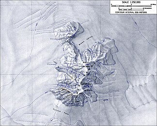
Topographic map of the Ames Range |
||
| Highest peak | Mount Andrus ( 2978 m ) | |
| location | Marie Byrd Land , West Antarctica | |
|
|
||
| Coordinates | 75 ° 42 ′ S , 132 ° 20 ′ W | |
The Ames Range is a mountain range in the Marie Byrd Land in western Antarctica . It is formed by the three connected shield volcanoes Mount Andrus ( 2978 m ), Mount Kosciusko ( 2909 m ) and Mount Kauffman ( 2364 m ). The Gardiner Ridge connects Mount Kosciusko with Mount Kauffman. The snow-covered, steep-walled mountains with flattened peaks extend north-south over a length of around 32 km and are at right angles to the east end of the Flood Range .
Scientists from the United States Antarctic Service Expedition (1939–1941) discovered them on reconnaissance flights. The American polar explorer Richard Evelyn Byrd named it after his father-in-law Joseph Blanchard Ames (1846–1915).
Web links
- Ames Range in the Geographic Names Information System of the United States Geological Survey (English)
- Ames Range on geographic.org (English)
- Andrus in the Global Volcanism Program of the Smithsonian Institution (English)

