Flood range
| Flood range | ||
|---|---|---|
|
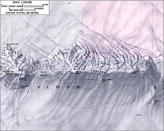
Topographic map of the western section of the Flood Range |
||
| Highest peak | Mount Berlin ( 3478 m ) | |
| location | Marie Byrd Land , West Antarctica | |
|
|
||
| Coordinates | 76 ° 3 ′ S , 134 ° 30 ′ W | |
The Flood Range is a mountain range in Marie Byrd Land in West Antarctica . It consists of high, snow-covered mountains that extend east-west over a length of around 100 km and are at right angles to the southern end of the Ames Range .
From east to west, the mountain range consists of the three large mountain ranges of Mount Bursey , Mount Moulton and Mount Berlin made up of shield volcanoes . At around 10 million years old, Mount Bursey is the oldest of these volcanoes, while Mount Berlin is the youngest at around 2.5 million years. Eruptions from Mount Berlin continued into the Holocene ; at present, volcanic activity is limited to fumaroles .
The American polar explorer Richard Evelyn Byrd discovered them from a great distance in 1934. Scientists from the United States Antarctic Service Expedition (1939–1941) explored them on reconnaissance flights. The Advisory Committee on Antarctic Names transferred Byrd's designation Mount Hal Flood for the highest point to the entire mountain range in an abbreviated form. It is named after the American politician and Byrd's uncle Henry D. Flood (1865–1921).
Web links
- Berlin in the Global Volcanism Program of the Smithsonian Institution (English).
- Bursey in the Global Volcanism Program at the Smithsonian Institution .
- Flood Range in the Geographic Names Information System of the United States Geological Survey .
- Flood Range on geographic.org (English).
Individual evidence
- ^ Matthew R. Patrick, John L. Smellie, Synthesis A spaceborne inventory of volcanic activity in Antarctica and southern oceans, 2000-10 . In: Antarctic Science . tape 25 , no. 4 , August 2013, ISSN 0954-1020 , Antarctica and adjacent islands: Mount Berlin, Mount Kauffman, Mount Siple, p. 481 , doi : 10.1017 / S0954102013000436 (English).

