Mount Moulton
| Mount Moulton | ||
|---|---|---|
| height | 3078 m | |
| location | Marie Byrd Land , Antarctica | |
| Mountains | Flood range | |
| Coordinates | 76 ° 3 ′ 0 ″ S , 135 ° 8 ′ 0 ″ W | |
|
|
||
| Type | Shield volcanoes , extinguished | |
|
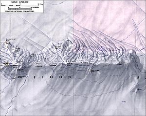
Mount Moulton topographic map (1: 250,000 scale) |
||
The Mount Moulton is a 3078 m high and icy mountain range in the West Antarctic Marie Byrd Land . It rises 16 km east of Mount Berlin in the center of the Flood Range , extends for around 30 km in a west-east direction and is formed by two overlapping shield volcanoes . Their age was determined to be almost 5 million years. On the north slope of the mountain are the steep Moulton Icefalls .
Scientists from the United States Antarctic Service Expedition (1939–1941) discovered the mountain in 1940 during overflights. It is named after Richard Stanley Moulton (1917–2000), the main dog sled driver at West Base and member of a research group who sleighed to the western end of the Flood Range in December of the same year.
Web links
- Antarctica Detail - Mount Moulton in the Geographic Names Information System of the United States Geological Survey .
- Moulton, Mount, Antarctica. In: Geographical Names . Geographic.org (English).
- Skiing the Pacific Ring of Fire and Beyond: Mount Moulton. In: skimountaineer.com. Amar Andalkar (English).
Individual evidence
- ↑ Lucia Sala Simian: Literature Review (Anta 502): The volcanoes of Marie Byrd Land and their importance in understanding the tectonics of West Antarctica as well as the reconstruction of the West Antarctic ice sheet (WAIS) in the last interglacial. (PDF; 123 kB) Graduate Course in Antarctic Studies 2004–2005. University of Canterbury , January 10, 2005, accessed August 24, 2017 .


