Amguema (river)
|
Amguema Амгуэма, Амгуема (Amgujema), Вульвывеем (Wulwywejem) |
||
|
|
||
| Data | ||
| Water code | RU : 19030000112119000087564 | |
| location | Chukchi Autonomous Okrug (Russia) | |
| River system | Amguema | |
| source | in the Chukotka highlands 67 ° 47 ′ 37 ″ N , 177 ° 27 ′ 32 ″ E |
|
| muzzle | In the Chukchi Sea coordinates: 68 ° 14 ′ 35 ″ N , 177 ° 33 ′ 22 ″ W 68 ° 14 ′ 35 ″ N , 177 ° 33 ′ 22 ″ W |
|
| Mouth height |
0 m
|
|
| length | 498 km | |
| Catchment area | 28,100 km² | |
| Discharge at gauge U mosta A Eo : 26,400 km² Location: 121 km above the mouth |
MQ 1944/1987 Mq 1944/1987 |
267 m³ / s 10.1 l / (s km²) |
| Left tributaries | Ekityki | |
|
Course of the Amguema |
||
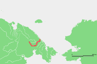
The Amguema ( Russian Амгуэ́ма ; also Amgujema , Russian Амгуема ) is a river in the Chukchi Autonomous Okrug in northeast Siberia .
The Amguema rises in the Chukotka highlands . From there it flows in a wide arc, first to the east and later to the north, before flowing into the Chukchi Sea after 498 km . The catchment area covers 28100 km². 121 km before the mouth, the average discharge of the Amguema is 267 m³ / s. In the upper reaches, the Amguema is also called Wulwywejem ( Вульвывеем ). The largest tributary of the Amguema is the Ekityki from the left.
Individual evidence
- ↑ a b Amguema in the State Water Directory of the Russian Federation (Russian)
- ↑ a b Article Amguema in the Great Soviet Encyclopedia (BSE) , 3rd edition 1969–1978 (Russian)
- ↑ a b Amguema at the U mosta gauge - hydrographic data at R-ArcticNET
