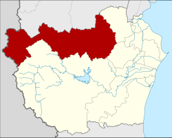
Amphoe Nong Ya Plong
|
Nong Ya Plong หนองหญ้าปล้อง |
|
|---|---|
| Province: | Phetchaburi |
| Surface: | 1249.8 km² |
| Residents: | 15,527 (2013) |
| Population density : | 11.5 U / km² |
| ZIP : | 76160 |
| Geocode : | 7603 |
| map | |

|
|
Amphoe Nong Ya Plong ( Thai : อำเภอ หนองหญ้าปล้อง ) is a district ( Amphoe - administrative district) in the north-western part of Phetchaburi Province . Phetchaburi Province is located in the southwestern part of the central region of Thailand .
geography
Neighboring districts (clockwise from north): the Ban Kha and Pak Tho districts of Ratchaburi Province and the Khao Yoi , Ban Lat and Kaeng Krachan districts of Phetchaburi Province. To the west lies the Tanintharyi Division of Myanmar .
history
Nong Ya Plong was initially set up on July 6, 1972 as a “branch circle” ( King Amphoe ) by separating the three tambon Nong Ya Plong, Yang Nam Klat Nuea and Yang Nam Klat Tai from the Amphoe Khao Yoi . On May 21, 1990, it got full amphoe status.
administration
Provincial Administration
Nong Ya Plong County is divided into four tambon ("subdistricts" or "parishes"), which are further subdivided into 31 muban ("villages").
| No. | Surname | Thai | Muban | Pop. |
|---|---|---|---|---|
| 1. | Nong Ya Plong | หนองหญ้าปล้อง | 11 | 6,843 |
| 2. | Yang Nam Klat Nuea | ยาง น้ำ กลัด เหนือ | 5 | 2,063 |
| 3. | Yang Nam Klat Tai | ยาง น้ำ กลัด ใต้ | 7th | 2,644 |
| 4th | Tha Takhro | ท่า ตะคร้อ | 8th | 3,977 |
Local administration
In the district there are three " tambon administration organizations " ( องค์การ บริหาร ส่วน ตำบล - Tambon Administrative Organizations, TAO)
- Nong Ya Plong (Thai: องค์การ บริหาร ส่วน ตำบล หนองหญ้าปล้อง ) consisting of the complete Tambon Nong Ya Plong.
- Yang Nam Klat Tai (Thai: องค์การ บริหาร ส่วน ตำบล ยาง น้ำ กลัด ใต้ ) consisting of the complete tambon Yang Nam Klat Nuea, Yang Nam Klat Tai.
- Tha Takhro (Thai: องค์การ บริหารส่วน ตำบล ท่า ตะคร้อ ) consisting of the complete tambon Tha Takhro.
Individual evidence
- ↑ ประกาศ กระทรวง มหาดไทย เรื่อง แบ่ง ท้องที่ อำเภอ เขาย้อย จังหวัด เพชรบุรี ตั้ง เป็น กิ่ง อำเภอ หนองหญ้าปล้อง . In: Royal Gazette . 89, No. 102 ง , July 4, 1972, p. 1717.
- ↑ พระราชกฤษฎีกา ตั้ง อำเภอ ห้วย ผึ้ง อำเภอ วัง วิเศษ อำเภอ คลอง หาด อำเภอ ป่า บอน อำเภอ หนองหญ้าปล้อง อำเภอ วัง โป่ง อำเภอ ควน เนียง อำเภอ หนอง หนอง หญ้า ไซ อำเภอ บ้านนาเดิม อำเภอ ทุ่งฝน อำเภอ สร้างคอม และ อำเภอ ทอง แสน ขัน พ.ศ. ๒๕๓๓ Royal Gazette, Vol. 107, Ed. 83 ก special ( ฉบับ พิเศษ ), May 21, 1994, pp. 1–4 (in Thai)
- ↑ 2013 population statistics ( Thai ) Department of Provincial Administration. Retrieved September 11, 2014.
Web links
Coordinates: 13 ° 10 ' N , 99 ° 42' E
