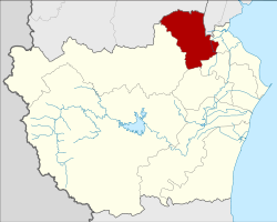
Khao Yoi district
|
Khao Yoi เขาย้อย |
|
|---|---|
| Province: | Phetchaburi |
| Surface: | 305.648 km² |
| Residents: | 38,331 (2013) |
| Population density : | 123.3 U / km² |
| ZIP : | 76140 |
| Geocode : | 7602 |
| map | |

|
|
Amphoe Khao Yoi ( Thai : อำเภอ เขาย้อย ) is a district ( Amphoe - administrative district) in the northern part of Phetchaburi Province . Phetchaburi Province is located in the southwestern part of the central region of Thailand .
geography
Neighboring districts are (from north clockwise): Amphoe Pak Tho the province of Ratchaburi , Amphoe Bang Khonthi the province of Samut Songkhram and Amphoe Ban Laem , Mueang Phetchaburi , Ban Lat and Nong Ya Plong Phetchaburi Province.
history
The county was established in 1897, and Luang Phromsan ( หลวงพรหม สาร) was appointed as the first governor . The district was initially called Huai Tha Chang, then in 1903 the name was changed to Hua Saphan and Ban Noi, as the administrative authority was relocated to the respective tambon until it was finally called Khao Yoi.
administration
Provincial Administration
The district of Khao Yoi is divided into ten tambon ("sub-districts" or "parishes"), which are further subdivided into 58 muban ("villages").
| No. | Surname | Thai | Muban | Pop. |
|---|---|---|---|---|
| 1. | Khao Yoi | เขาย้อย | 6th | 7.149 |
| 2. | Sa Phang | สระ พัง | 4th | 3,364 |
| 3. | Bang Khem | บาง เค็ม | 6th | 3,772 |
| 4th | Thap Khang | ทับ คาง | 5 | 3,500 |
| 5. | Nong Pla Lai | หนอง ปลา ไหล | 5 | 2,684 |
| 6th | Nong Prong | หนอง ปรง | 6th | 3,846 |
| 7th | Nong Chumphon | หนอง ชุมพล | 7th | 4,826 |
| 8th. | Huai Rong | ห้วย โรง | 4th | 2,588 |
| 9. | Huai Tha Chang | ห้วย ท่าช้าง | 8th | 1.956 |
| 10. | Nong Chumphon Nuea | หนอง ชุมพล เหนือ | 7th | 4,646 |
Local administration
There is one municipality with "small town" status ( Thesaban Tambon ) in the district:
- Khao Yoi (Thai: เทศบาล ตำบล เขาย้อย ) consisting of the complete Tambon Bang Khem and the parts of the Tambon Khao Yoi, Sa Phang, Thap Khang.
In addition, there are seven " Tambon Administration Organizations " ( องค์การ บริหาร ส่วน ตำบล - Tambon Administrative Organizations, TAO)
- Khao Yoi (Thai: องค์การ บริหาร ส่วน ตำบล เขาย้อย ) consisting of the parts of the tambon Khao Yoi, Sa Phang, Thap Khang.
- Nong Pla Lai (Thai: องค์การ บริหาร ส่วน ตำบล หนอง ปลา ไหล ) consisting of the complete tambon Nong Pla Lai.
- Nong Prong (Thai: องค์การ บริหาร ส่วน ตำบล หนอง ปรง ) consisting of the complete Tambon Nong Prong.
- Nong Chumphon (Thai: องค์การ บริหาร ส่วน ตำบล หนอง ชุมพล ) consisting of the complete Tambon Nong Chumphon.
- Huai Rong (Thai: องค์การ บริหาร ส่วน ตำบล ห้วย โรง ) consisting of the complete tambon Huai Rong.
- Huai Tha Chang (Thai: องค์การ บริหาร ส่วน ตำบล ห้วย ท่าช้าง ) consisting of the complete tambon Huai Tha Chang.
- Nong Chumphon Nuea (Thai: องค์การ บริหาร ส่วน ตำบล หนอง ชุมพล เหนือ ) consisting of the complete Tambon Nong Chumphon Nuea.
Individual evidence
- ↑ แจ้ง ความ กระทรวง มหาดไทย เรื่อง เปลี่ยน ชื่อ อำเภอ พัน ลาน แขวง เมือง นครสวรรค์ เป็น อำเภอ เกย ไชย อำเภอ เกลือ แขวง เมือง ชลบุรี เป็น อำเภอ บางละมุง อำเภอ ท่าช้าง ท่าช้าง แขวง เมือง นครนายก เป็น เป็น อำเภอ บ้านนา อำเภอ ห้วย หลวง แขวง เมือง เพชรบุรี เป็น อำเภอ เขาย้อย . In: Royal Gazette . 20, No. 30, October 25, 1903, p. 498.
- ↑ 2013 population statistics ( Thai ) Department of Provincial Administration. Retrieved September 11, 2014.
Web links
Coordinates: 13 ° 14 ' N , 99 ° 49' E
