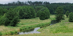
Kraina Węgorapy
| Kraina Węgorapy | ||
|---|---|---|
| location | Warmia-Masuria , Poland | |
|
|
||
| Coordinates | 54 ° 18 ′ N , 21 ° 51 ′ E | |
The Kraina Węgorapy (from the river Węgorapa , German Angerapp ) is a mesoregion and lake landscape in the Warmian-Masurian Voivodeship in Poland . The region has an area of 690 km².
location
The Kraina Węgorapy is the northernmost part of the Masurian Lake District , which already borders the Russian exclave Kaliningrad Oblast in the north. The Great Masurian Lakes join in the south, the Rominter Heide in the east and the Nizina Sępopolska (Schippenbeiler lowland) in the west. The region is located in north-eastern Poland.
geology
The Kraina Węgorapy originally consisted of a large number of large lakes in a moraine landscape. Characteristic of this landscape are glacial channels between the hills, created by the erosive effect of the meltwater when the glaciers melted , which later took up the lakes. Most of the lakes in the Kraina Węgorapy are now overgrown and silted up, so that the landscape consists mainly of moraines, swamps and peat areas.
structure
The Kraina Węgorapy is divided into three micro-regions:
- The hill country of Wyniesienie Pawłowskie, which is up to 161 meters above sea level, lies north of the Mamry when the Węgorapa emerges from it. The Węgorapa breaks through the moraine landscape in a deep and winding ravine .
- Downstream, the Niecka Skaliska basin joins , which is a large silted lake. Here the Węgorapa meanders with numerous river knees and oxbow lakes through a swamp and peat landscape. Here the Gołdapa joins the Węgorapa at an altitude of 97 meters above sea level. The area is partly overgrown with the Lasy Skaliskie jungle , which is a habitat for the bald eagle .
- To the east is the hill country Pagórki Rogalskie , which is up to 190 meters above sea level and is traversed by the Gołdapa, which breaks through the moraine landscape here. Here are the largest lakes in the region, including the Jezioro Czupowskie .
Lakes
The Kraina Węgorapy is located north of the Mamry , which is already one of the Great Masurian Lakes. With the exception of the eastern part of the region, most of the lakes here are already overgrown and silted up.
Rivers
The northern part of the Great Masurian Lakes drains north via the Węgorapa (Angerapp) into the Pregel , which flows through the region from southwest to northeast. The most important right tributary from the east is the Gołdapa (Goldap).
colonization
The Kraina Węgorapy area is very sparsely populated, even by the standards of the Masurian Lake District. Small towns like Węgorzewo (Angerburg) or Gołdap are already in the neighboring regions.
nature
The area is protected by the Masurian Landscape Protection Park, which also has numerous nature reserves.
literature
- Jerzy Kondracki: Geografia regionalna Polski. 2002, Warszawa, PWN, ISBN 83-01-13897-1 .


