Annandale (Virginia)
| Annandals | ||
|---|---|---|
 Annandale Community Park |
||
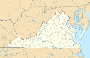
| Location in Virginia | ||
|
|
||
| Basic data | ||
| State : | United States | |
| State : | Virginia | |
| County : | Fairfax County | |
| Coordinates : | 38 ° 50 ′ N , 77 ° 13 ′ W | |
| Time zone : | Eastern ( UTC − 5 / −4 ) | |
| Residents : | 41,008 (as of 2010) | |
| Population density : | 1,148.7 inhabitants per km 2 | |
| Area : | 35.8 km 2 (approx. 14 mi 2 ) of which 35.7 km 2 (approx. 14 mi 2 ) is land |
|
| Height : | 110 m | |
| Postal code : | 22003 | |
| Area code : | +1 703 571 | |
| FIPS : | 51-01912 | |
| GNIS ID : | 1492474 | |
| Website : | www.annandale.va.us | |
Annandale is a census-designated place (CDP) in Fairfax County in the US state of Virginia .
geography
According to the United States Census Bureau , the area of Annadale extends to 35.8 km². 0.17% of this is water. The area is east of the Fall Line .
population
According to the 2000 census, 54,994 people live in Annadale. There are 19,927 households and 14,088 families.
economy
Annadale is the seat of various companies. The largest are Noblis , a subsidiary of Miter Corporation, and Computer Sciences Corporation .
Personalities
- Tony Cavalero (* 1983), actor and comedian
- Bilal Hamid (* 1990), football player
Web links
Commons : Annandale (Virginia) - Collection of images, videos, and audio files
