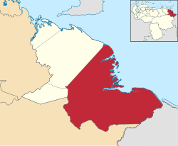
Antonio Díaz (Municipio)
| Antonio Díaz | |
|---|---|
 |
|
| Basic data | |
| Country | Venezuela |
| Capital | Curiapo |
| surface | 22,746 km² |
| Residents | 19,308 (2001) |
| density | 0.8 inhabitants per km² |
| ISO 3166-2 | VE-Y |
| politics | |
| Political party | PSUV |
Coordinates: 8 ° 35 ′ N , 61 ° 0 ′ W
Antonio Díaz is a district ( municipio ) in the state of Delta Amacuro , in northeast Venezuela . Most of the residents are Warao Indians. They still speak their language . The capital is Curiapo . 60% of Venezuela's Warao population resides in this community.
geography
In the north, the municipality consists of numerous islands in the Orinoco Delta . In the southeast is the Imataca mountain range. The largest islands are Isla Remolinos, Isla Tobejuba, Isla Caneima, Isla Ubudorojo, Isla Grande de Curiapo and Isla Corocoro. San Francisco de Wayo is a settlement with a Catholic mission.
There are hardly any paths, one moves mainly with small boats.
structure
Antonio Díaz is divided into six parroquias (with main towns) at the lowest administrative level :
- Parroquia Curiapo, Curiapo.
- Parroquia Almirante Luis Brión, Manoa.
- Parroquia Francisco Aniceto Lugo, Boca de Cuyubini.
- Parroquia Manuel Renaud, Araguabisi.
- Parroquia Padre Barral, San Francisco de Guayo.
- Parroquia Santos de Abelgas, Araguaimujo.
