Ao Nang
|
อ่าว นาง Ao Nang |
||
|---|---|---|
|
|
||
| Coordinates | 8 ° 3 ' N , 98 ° 49' E | |
| Basic data | ||
| Country | Thailand | |
| Krabi | ||
| ISO 3166-2 | TH-81 | |
|
Ao Nang street scene
|
||
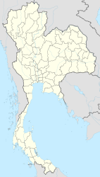
Ao Nang ( Thai อ่าว นาง , roughly “Ladies Bay”) is a place in the Krabi Province in southern Thailand . Ao Nang is also the administrative seat and largest place of the municipality of the same name ( Tambon ) in the district ( Amphoe ) Mueang Krabi .
location
The small town with almost 8,000 inhabitants is about 20 kilometers west of the provincial capital Krabi , it is located on the eastern edge of the Bay of Phang-nga , a sea inlet of the Andaman Sea .
economy
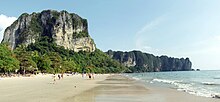
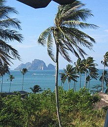
Originally a small fishing village, Ao Nang has developed from an insider tip for backpackers to a highly frequented destination for international mass tourism since the 1990s . The place has almost completely abandoned its original structures and has adjusted its entire infrastructure to tourism, which has become by far the most important economic factor in Ao Nang. This development was favored by the approximately two kilometer long Ao Nang Beach, which is located directly on site, with its view of the offshore islands, as well as the convenient location to the Krabi Airport (KBV), which is only 30 kilometers away.
Attractions
There are no cultural sights to be found in Tambon Ao Nang. In contrast, the tropical nature in the vicinity offers, among other things, these sights:
- Hat Noppharat Thara National Park - Mu Ko Phi Phi (Thai: อุทยานแห่งชาติ หาด นพรัตน์ ธารา - หมู่ เกาะ พี พ ), to which the beach of Ao Nang also belongs,
- Nopparat Thara Beach (Thai: หาด นพรัตน์ ธารา ) is also part of the national park, it is located approx. 1 km west of Ao Nang Beach,
- the beach of the peninsula Rai Leh (also: Raleigh or Railay , Thai : อ่าว ไร่ เล ย์ ) is about 5 km southeast of the main beach of Ao Nang,
- as well as other smaller caves.
A little further away:
- The Than-Bok-Khorani National Park (Thai: อุทยานแห่งชาติ ธาร โบกขรณี ) with the Than-Bok-Khorani waterfall, natural pools and numerous grottos, some of which have prehistoric cave paintings, is located in the Ao Luek district in the north-west of the province,
- the stalactite cave Tham Phet ( diamond cave - because of the glittering stalagmites and stalactites ) is 3 km from Ao Luek Nuea, Amphoe Ao Luek also in the northwest of Krabi province,
- the cave temple Wat Tham Sua with the tiger cave ( ถ้ำ เสือ - Tham Suea) is located about 10 km north of the provincial capital Krabi.
history
The tsunami caused by the seaquake in December 2004 also reached Ao Nang. Due to the limestone cliffs in front of it, which functioned as a breakwater, the damage was limited compared to other coastal towns in the region.
administration
The Tambon Ao Nang is divided into eight localities ( Muban ) .
| No. | Surname | Thai | |
|---|---|---|---|
| 1. | Baan Chong Phli | บ้านช่อง พลี | |
| 2. | Baan Ao Nang | บ้าน อ่าว นาง | |
| 3. | Baan Khlong Haeng | บ้าน คลอง แห้ง | |
| 4th | Baan Na thin | บ้านนา ตีน | |
| 5. | Baan Thung | บ้าน ทุ่ง | |
| 6th | Baan Khlong Som | บ้าน คลอง สน | |
| 7th | Baan Ko Phi Phi | บ้าน เกาะ พี พี | |
| 8th. | Baan Laem Thong | บ้านแหลม ต ง |
Web links
- Hat Noppharat Thara - Mu Ko Phi Phi National Park by the Thai Department of National Parks - Description in English [last accessed on November 9, 2011]
- 1995 Thai Navy topographic map: Entrance to Krabi


