Aoraki / Mount Cook (New Zealand)
| Aoraki / Mount Cook | ||
| Geographical location | ||
|
|
||
| Coordinates | 43 ° 44 ′ S , 170 ° 6 ′ E | |
| Region ISO | NZ-CAN | |
| Country |
|
|
| region | Canterbury | |
| District | Mackenzie District | |
| Ward | Pukaki Ward | |
| Residents | 192 (2013) | |
| height | 700 m | |
| Post Code | 7999 | |
| Telephone code | +64 (0) 3 | |
| Photography of the place | ||
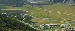
 Aoraki / Mount Cook (Mount Cook Village) |
||
Aoraki / Mount Cook is a small place in the Mackenzie District in the Mount Cook National Park s .
geography
The place is about 16 km south of the Aoraki / Mount Cook , the highest mountain in New Zealand , and is thus 7 km south of the Hooker glacier . The place had 192 inhabitants in the 2013 census.
The place
The village is a tourist center and serves as a starting point for mountaineers. The first building in town was the Hotel The Hermitage , founded in 1884 (44 years after the Treaty of Waitangi ) . The company still exists today - however, the original building was destroyed in a flood in 1913.
It was not until the 1950s and 1960s that more youth hostels and motels were built, which led to an increase in visitor numbers.
Web links
- Information page of the regional Visitor Information Center (English)
- Tourism New Zealand information page with map
Individual evidence
- ↑ a b 2013 Census QuickStats about a place: Mt Cook . Statistics New Zealand , accessed August 5, 2016 .
- ↑ Topo250 maps . Land Information New Zealand , accessed August 5, 2016 .
