
Arnsberg city wall

In the Middle Ages and early modern times, the Arnsberg city wall surrounded the then built-up urban area of Arnsberg . A first fortification around the original settlement core was built immediately after the settlement in the 12th century. In the 13th century, the fortifications were expanded to include the lower town and the Wedinghausen monastery was also included. The actual city received a massive stone wall and had several towers and gates. There was no noteworthy modernization in the early modern period. Some of the walls were demolished at the end of the 18th and beginning of the 19th century, but some houses were also built on them. Some remains of the city wall and towers have been preserved.
location
The old town of Arnsberg lies on a ridge around which the Ruhr flows from both sides. The main danger came from the south. At the highest point of the saddle that made Count of Werl-Arnsberg the Arnsberg Castle built.
history
First fortifications
People settled below the castle in the outer bailey. In 1114 fourteen free families submitted to Count Friedrich . The first buildings in front of the castle formed an oval and were protected by a wide neck moat . This first defense system extended from the later Green Tower over the Küttelberg to the Hanstein. Burgmann houses were important areas of defense.
Other people soon settled outside the neck ditch in the area of what would later become the Upper Town. Initially as an earth-wood wall, the settlement was surrounded by fortifications no later than the second half of the 12th century. The bell tower formed the particularly endangered and therefore strong southern city gate. It is unclear when exactly the tower was built. It existed before Count Gottfried III. , who announced shortly after the beginning of his rule around 1238 that he would grant the settlement freedom rights. To the north of the bell tower there are comparatively large pieces of land that indicate Burgmann houses in this area.
The Burgsmann houses include the forerunners of the Weichs'schen Hof , the Dücker Hof and today's Kolping Society. The Burgmann houses were solidly built, at least in their lower areas; they had loopholes and large vaults for storing supplies.
Stone walls
In front of the bell tower there was another settlement (lower town). In the mentioned document of Count Gottfried III. there is talk of the intention to include this settlement with a second wall in the existing fortification. This initially extends to today's Lindenberg. In the second half of the 13th century, the wood-earth wall was replaced by a wall made of rubble stones with corresponding towers and gates.
In the direction of the Wedinghausen monastery, the monastery gate stood as a new southern entrance to the city. As a result, the bell tower lost its character as the main fortification tower and became an inner-city gate.
Western area: The Honkampsturm, near today's administrative court , was demolished at the end of the 19th century. The mill gate was in the direction of the mill ditch. Limps Tower was part of the fortification of the upper town of Arnsberg and a gate system, the Limps gate. It is a five-storey, semicircular wall tower made of quarry stone with a slated cone dome. He was provided with numerous loopholes.
The next tower was the Green Tower. It is a two-story corner tower of the city fortifications. This is a shell tower made of quarry stone from the middle of the 13th century. The city wall bends here and now leads up the slope towards the castle hill. Remnants of the moat can still be seen between the Green Tower with the adjoining wall, which roughly marks the course of the city wall, and the Oberfreistuhl opposite . The former hook tower no longer exists. An important gate was the oleyporte. Through this the road to Soest led into the city. The entrance to the castle was reached through the castle gate.
Eastern area: The eastern wall stretched directly on the mountainside to the castle. It was interrupted by the no longer existing bird gate on Tillmanns Gäßchen and the still existing imperial gate. The gate was below the castle.
In front of the curtain wall there was a deep trench, at least in the western and southern areas. A path ran on the town side to allow quick access to the towers and defenses.
The preservation of the walls and their manning in the event of a defense was a matter for the citizens. The individual guilds were responsible for the various sections. The Limpstor, for example, was subordinate to the blacksmiths' guild.
The Wedinghausen monastery was also included in the fortification with ramparts and ditches. However, the area between the monastery gate and the monastery itself remained undeveloped. On city views from the early modern period, the area between the monastery and the city was secured with simple palisades. The protective effect was accordingly limited, as was shown by the siege of the city by Eberhard Beckermann , who could easily take the monastery. Similar to the monastery, the municipal mill on the Ruhr was connected to the city fortifications by its own enclosure.

Before the wall was expanded, the bell tower was the main southern entrance to the city

The Kaiserpförtchen was a small wall gate.
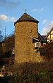
The Green Tower was a corner tower in the city fortifications

Limps Tower was part of a gate system

Small shell tower in the street Unterm Tempel


Further development
The Landsberger Hof was built over part of the eastern city wall in the 17th century . After the walls had lost their importance as defensive structures in the 18th century with the advent of better war techniques, houses were built on the walls. So a small house was built on the imperial gate. This overbuilding of the wall shapes the appearance of the city in the east to this day.
The walls enclosed the city area until 1799. Only after the city fire of 1799 were new streets and houses built outside the mill gate and the monastery gate. Large parts of the walls were demolished in the west and south. Remnants have been preserved in some areas and the course of the wall can thus also be traced relatively well in the west. Last but not least, the preserved towers shape the cityscape. The location of the monastery gate, which burned down in 1799 and was not rebuilt, will be made visible again in the street space in 2015 by a light installation by the artist Santiago Sierra entitled The Dept.
Individual evidence
literature
- Hermann Herbold: Old Arnsberg - grown and planned. In: Heimatblätter of the Arnsberger Heimatbund. 1/1980, pp. 4-6.
- Karl Féaux de Lacroix : History of Arnsberg. HR Stein-Verlag, Arnsberg 1895. (Reprint: Stein, Werl 1983, ISBN 3-920980-05-0 , pp. 79-80)
- Klemens Pröpper: From Saustraße, Bindfadengasse and Oleypforte . In: Heimatblätter of the Arnsberger Heimatbund. 8/1997, pp. 23-31.
- Uwe Haltaufderheide: The architectural monuments of the city of Arnsberg. Collection period 1980–1990. City of Arnsberg, Arnsberg 1990, ISBN 3-928394-01-0 .
- Heinz Pardun: Honkamps Tower. In: Heimatblätter of the Arnsberger Heimatbund. 12/1991, pp. 14-18.
- Franz Kessler: Forgotten streets and towers. The structural development of the city of Arnsberg until 1800. In: Günter Cronau (arrangement): Franz Kessler - cross instead of swastika. Arnsberg 2002, pp. 290-294.