Arthur Range (Australia)
| Arthur Range | ||
|---|---|---|
|
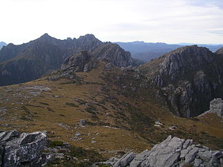
View from Mount Columba over the High Moor to Mount Capricorn and Mount Pegasus |
||
| Highest peak | Federation Peak ( 1224 m ) | |
| location | Tasmania | |
| part of | Great dividing range | |
|
|
||
| Coordinates | 43 ° 12 ′ S , 146 ° 25 ′ E | |
| rock | Quartzite | |
The Arthur Range is a mountain range in the southwest of the Australian state of Tasmania and part of the Great Dividing Range . The mountain range is south of Lake Pedder in Southwest National Park and is divided into two parts, the Western Arthurs and the Eastern Arthurs . Both parts are very popular with hikers, especially in summer.
history
The mountain range was named by George Augustus Robinson when he climbed Mount Frederick (now Mount Hayes ) in March 1830 .
geology
The Arthur Range consists mainly of quartzite and shows traces of earlier glaciation , such as moraines and high valleys.
Flora and fauna
Much of the Arthur Range and its surroundings with sedge ( Mesomelaena sphaerocephala coverage). Eucalyptus forests spread over the remaining areas .
The most common of all animals are birds (e.g. the black cockatoo ). Filanders can also be found in drier locations .
climate
The climate in the Arthur Range is very changeable. Weather forecasts are hardly useful because there is often sun, heavy rain, clouds, strong winds and even snowfall on the same day. The highest peak is classified as alpine or subalpine. In winter all the peaks are covered with snow, but there is also often heavy snowfall in summer, even if the snow does not stay. The climate is mainly determined by the wind. The temperatures can change very quickly from very warm with winds from the north of Tasmania to very cold with winds from the Southern Ocean or the Antarctic .
hikes
As in other parts of southwest Tasmania, the trails are often very muddy, sometimes more than ankle-deep. Even in the higher regions you still have to struggle with this mud, unless bare rock comes to light.
Another problem is the frequent occurrence of Phytophtora (root rot) in Tasmania . In order to prevent further spread, one should stay on the created paths. In addition, you are asked to walk in the middle of the path, even if it is muddy, so that the plants along the path are not trampled.
Hikers should prepare for changing weather conditions and always have food with them for an additional 1–2 days.
Western Arthurs
The Western Arthurs extend in a northwest-southeast direction from Mount Hesperus to the west portal . This part of the mountain range was crossed for the first time in the early 1960s.
The Western Arthurs are best accessed from the Scotts Peak Dam campsite via the first section of the Port Davey Track .
![]()
Lakes
The Western Arthurs are peppered with many lakes created by the glaciers of the Ice Age. These are e.g. B .:
- Lake Oberon ( ): There are also tent possibilities there.

- Lake Cygnus ( ): also tent possibilities

- Lake Ceres ( )

- Square Lake ( )

- Lake Fortuna ( )

Eastern Arthurs

The Eastern Arthurs extend in a north-south direction from the eastern end of the Western Arthurs. They also include the highest peak in the mountains, the steep rock needle of Federation Peak . This part of the mountain range was first crossed in December 1947 by a group from the Hobart Walking Club .
Individual evidence
- ↑ Kevin Doran: Federation: Australia's Adventure Peak . Desdichado, 2004, ISBN 0-9586935-1-X , p. 14.
- ^ John Chapman: South West Tasmania , 4th Edition, John Chapman, 1998, ISBN 0-9596129-5-5 , p. 12.
- ^ John Chapman: South West Tasmania , 4th Edition, John Chapman, 1998, ISBN 0-9596129-5-5 , p. 144.


