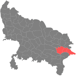
Azamgarh (Division)
| Azamgarh Division | |
|---|---|
| State : | Uttar Pradesh |
| Coordinates | 26 ° 4 ′ N , 83 ° 11 ′ E |
| Administrative headquarters : | Azamgarh |
| Area : | 8,748 km² |
| Residents : | 10,059,655 |
| Population density : | 1,150 inhabitants / km² |
| Districts : | 3 |
The Azamgarh Division is a division in the Indian state of Uttar Pradesh . The administrative headquarters are in the city of Azamgarh .
Districts
The Azamgarh Division is divided into three districts :
| District | Administrative headquarters | Area in km² | Population (2011) | Ew./km² |
|---|---|---|---|---|
| Azamgarh | Azamgarh | 4,054 | 4,613,913 | 1,138 |
| Ballia | Ballia | 2,981 | 3,239,774 | 1,087 |
| Mau | Mau | 1,713 | 2,205,968 | 1,288 |
Individual evidence
- ↑ Divisions of Uttar Pradesh Administrative Divisions of Uttar Pradesh In Uttar Pradesh, there are 18 Divisions, 72 districts, 821 blocks, 52021 Panchayat and 107452 villages. BrandBharat.com. Retrieved August 11, 2019 .
- ^ Indian Districts by Population, Sex Ratio, Literacy 2011 Census. Retrieved August 11, 2019 .
