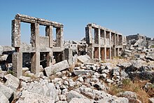
Ba'uda (Jebel Barisha)
Ba'uda or Baude (also Ba'udeh and Bawde; ) was an early Byzantine settlement and a small trading center in the Dead Cities area in northwest Syria .
location
The ruins of Ba'uda are located in the Idlib governorate on the northern slope of the Jebel Barischa, in the central part of the northern Syrian limestone massif, within sight of the Bab al-Hawa border crossing located two kilometers away in the valley. The road from Aleppo to the west runs through this valley via the Turkish city of Reyhanlı to Antakya . In the mostly Kurdish , less fertile and karst rocky hills there are several other ruins. About two kilometers south is the ancient place Babisqa , six kilometers west is Baqirha , a few 100 meters north of this Dar Qita . From Barqira an asphalt road leads about six kilometers south to the larger early Byzantine settlement of Barischa with several oil presses. The most famous place in the region is because of its church Qalb Loze , which is eight kilometers west of Barischa on the parallel Jebel Ala, which runs in a north-south direction.
Ba'uda should not be confused with the ruins of the same name , which lies in the southern part of the limestone massif between al-Bara and Serjilla and is mentioned for its pyramid tomb.
Cityscape
The earliest surviving houses of Ba'uda and most of the Dead Cities date back to the 4th century, with their heyday in the 5th and 6th centuries. In Ba'uda, entire rows of houses with two-story pillar porticos have been preserved. They formed a covered passage in front of the houses, in which there were shops on the ground floor and living rooms above. Massive limestone slabs were set between the posts on the upper floors, some of which are still in situ .
In 1905, Howard Crosby Butler found the remains of a small church, which had already been almost completely destroyed at that time and which he dated to 392 according to an inscription. The Greek inscription was walled up with the stone upside down, apparently by a craftsman who could not read it. Butler suspected a semicircular apse with side rooms and a straight east wall on the barely recognizable east side . The nave had an unusual, almost square shape. The arcade high walls of the three-aisled basilica with a row of arched windows in the upper area were each supported by three columns. The only two entrances were in the south wall, to which a walled courtyard was attached. The east of the two doors bears the name of the architect: "Markianos Kyris". The western door contained the date of completion, which could not be read with certainty. In the nave, all the capitals have been preserved in a disturbed find position, they show Tuscan and Ionic style variants. In 1941 and 1970 a rough construction survey was carried out by Georges Tchalenko.
300 meters southwest is a modern agricultural settlement with about a dozen houses. There are some other ancient ruins built into the farmsteads, which serve as stables for goats and geese.
Barischa, Ba'uda, Barqira and Dar Qita were the economic centers in the Jebel Barischa area, which gained prosperity from the export of olive oil and wine and the trade in goods for daily needs.
literature
- Frank Rainer Scheck, Johannes Odenthal: Syria. High cultures between the Mediterranean and the Arabian desert. DuMont, Cologne 1998, p. 305, ISBN 3-7701-1337-3
Individual evidence
- ^ Hermann Wolfgang Beyer : The Syrian church building. Studies of late antique art history. Walter de Gruyter, Berlin 1925, p. 94 f
- ^ Howard Crosby Butler: Early Churches in Syria. Fourth to Seventh Centuries. Princeton University Press, Princeton 1929, p. 35
- ↑ Christine Strube : Building decoration in the northern Syrian limestone massif. Vol. I. Forms of capitals, doors and cornices in the churches of the 4th and 5th centuries AD. Philipp von Zabern, Mainz 1993, pp. 47–49


