
Bachum Bach
| Bachum Bach | ||
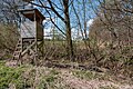
 Upper course at Bachum-Dreihausen |
||
| Data | ||
| Water code | DE : 276312 | |
| location | North Rhine-Westphalia , Germany | |
| River system | Rhine | |
| Drain over | Ruhr → Rhine → North Sea | |
| source | North of the village of Dreihausen in Bachum 51 ° 27 ′ 2 ″ N , 7 ° 55 ′ 45 ″ E |
|
| Source height | 238 m above sea level NN | |
| muzzle | Border between Bachum and Neheim in the Ruhr Coordinates: 51 ° 28 ′ 10 ″ N , 7 ° 56 ′ 42 ″ E 51 ° 28 ′ 10 ″ N , 7 ° 56 ′ 42 ″ E |
|
| Mouth height | 149 m above sea level NN | |
| Height difference | 89 m | |
| Bottom slope | 30 ‰ | |
| length | 2.9 km | |
| Catchment area | 2.15 km² | |
The Bachumer Bach is a 2,938 meter long, orographically left tributary of the Ruhr in the North Rhine-Westphalian Arnsberg , for the most part as a border brook between the districts of Bachum and Bergheim ( belonging to Neheim ). The stream rises north of the village of Dreihausen (belonging to Bachum) at an altitude of 238 m above sea level. NN and flows in a northerly direction to 149 m above sea level. NN in the Ruhr.
The stream overcomes a height difference of 89 m on its way, which corresponds to a mean bed gradient of 30.3 ‰ over a length of 2.938 km. The brook drains over the Ruhr and the Rhine to the North Sea .
nature and environment
Large parts of the stream are designated as protected landscape components. The lower course lies in the Ruhraue nature reserve . The dipper occurs by the stream.
High seat on the upper reaches

deep stream bed

Drain into the Ruhr


