Baengnyeongdo
| Baengnyeongdo | ||
|---|---|---|
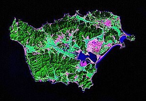
| Landsat image of Baengnyeong | ||
| Waters | Yellow Sea | |
| Geographical location | 37 ° 57 ′ 0 ″ N , 124 ° 40 ′ 0 ″ E | |
|
|
||
| surface | 45.8 km² | |
| Highest elevation |
Yonggiwon-san 136 m |
|
| Residents | 4329 (1999) 95 inhabitants / km² |
|
| main place | Jinchon | |
| Location of Baengnyeong | ||
| Korean spelling | |
|---|---|
| Korean alphabet : | 백령도 |
| Hanja : | 白翎 島 |
| Revised Romanization : | Baengnyeongdo |
| McCune-Reischauer : | Paengnyŏngdo |
The Baengnyeongdo (also Baekryeong Island is) the western island of South Korea . It is located in the Yellow Sea , about 15 kilometers off the coast of the North Korean province of Hwanghae-namdo . In the 1953 ceasefire agreement, Baengnyeong-do was assigned to South Korea and has since been part of Ongjin County in the urban area of Incheon . The island has an area of 45.8 km². The Northern Limit Line , the maritime demarcation line between North and South Korea, is about 7 km north of it. The island has a population of 4329 inhabitants (as of 1999). The main town is Jinchon (진촌). The highest point on the island, Yonggiwŏn-san , is near the eastern end and reaches a height of 136 meters.
The name of the island means "white wing island" as there is a population of ibis on the island .
Because of its proximity to North Korea, it has served as a base for secret service activities in South Korea and the US Army on several occasions . A number of North Korean refugees ended up here to escape the economic and political conditions in their home country. In the recent past there have been several maritime incidents in the area of the island, most recently the sinking of the South Korean warship Cheonan on March 26, 2010 , in which 46 soldiers were killed.
Web links
- Wikisource: 1953 Armistice Agreement - Baengnyeong-do (PAENGYONG-DO) is mentioned in Article II, Section 13 (b)
Individual evidence
- ↑ Sailing Directions (enroute), Pub. 157 (therein Paengnyong Do ; PDF; 4.3 MB, English)
- ↑ GeoNames 136 meters


