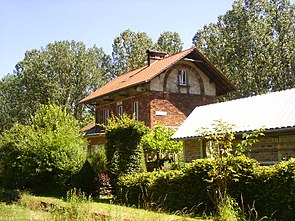
Zerf train station
| Zerf | |
|---|---|
|
Train station from the bike path
|
|
| Data | |
| Operating point type | railway station |
| Location in the network | Intermediate station |
| Design | Through station |
| Platform tracks | 2 |
| abbreviation | SZF |
| opening | 1889 |
| Conveyance | 1985 |
| location | |
| City / municipality | Zerf |
| country | Rhineland-Palatinate |
| Country | Germany |
| Coordinates | 49 ° 36 '25 " N , 6 ° 42' 21" E |
| Railway lines | |
|
|
| Railway stations in Rhineland-Palatinate | |
The Zerf Station is a former railway station on the Ruwertalbahn in Zerf in Rhineland-Palatinate .
history
Zerf station was built in 1889 together with the Ruwertalbahn.
In 1907/08, the station received an intersection and a ramp track of 550 m in length as well as a loading ramp of 250 m in length, which served to make the railway line usable for military purposes. However, these tracks were removed again in 1962. When the Ruwertalbahn was switched to train control operations between 1962 and 1965 , Zerf station lost its dispatcher and local staff.
Passenger traffic ended in 1984/86. However, trains still drove through the station to operate the Bilstein factory and some commercial facilities between Trier and Zerf. The section between Zerf and Schillingen was officially closed. The fact that the line was still used was because the line had to be kept operational for NATO , especially for the Hermeskeil barracks . As a result, special company trains also ran on the route. The route was officially closed in 1998 and then converted into a cycle path that has been continuously passable since 2009.
Station building and station area
The station building corresponds to the construction type of other station buildings on the Ruwertalbahn, for example the stations in Kell or Pluwig . From 1908 to the 1960s, there were also crossing and ramp tracks in the station. These were built for military purposes, but also used to load wood. With the construction of fallback switches in the 1960s, the signal box was dispensable. The station building, including the goods shed and the signal box extension, was sold as a residential building and has therefore been privately owned since 1981. The family who live in the train station now offers an apartment for tourists. The station building is a listed building .
The longest street in Zerf begins at Zerf train station and leads two kilometers from the train station into the center of the village.
Individual evidence
- ↑ a b c Axel Munsteiner: Life on the edge of the old tracks. In: volksfreund.de. October 11, 2013, accessed March 3, 2018 .
- ↑ a b c Zerf train station. (No longer available online.) In: hochwaldbahn.info. June 30, 1982, archived from the original on March 4, 2018 ; accessed on March 3, 2018 . Info: The archive link was inserted automatically and has not yet been checked. Please check the original and archive link according to the instructions and then remove this notice.
- ↑ Railway cycle paths - Ruwer-Hochwald cycle path (2). In: bahntrassenradwege.de. December 23, 2012, accessed March 3, 2018 .
- ↑ a b Bahnhofstrasse Zerf, SWR TV report on YouTube , from May 20, 2013
- ^ Ewald Wegner (arrangement): District of Trier-Saarburg. Verbandsgemeinden Ruwer, Schweich, Trier-Land (= monument topography Federal Republic of Germany , cultural monuments in Rhineland-Palatinate . Volume 12.2 ). Wernersche Verlagsgesellschaft, Worms 1994, ISBN 3-88462-110-6 .
