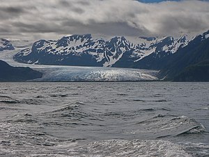
Bainbridge Glacier
| Bainbridge Glacier | ||
|---|---|---|
|
Bainbridge Glacier (2010) |
||
| location | Alaska ( USA ) | |
| Mountains | Kenai Mountains | |
| Type | Valley glacier | |
| length | 15.8 km | |
| surface | 32 km² | |
| Exposure | east | |
| Altitude range | 1350 m - | |
| width | ⌀ 1.4 km | |
| Coordinates | 60 ° 7 ′ N , 148 ° 26 ′ W | |
|
|
||
| drainage | → Port Bainbridge ( Gulf of Alaska ) | |
The Bainbridge Glacier is a valley glacier on the east coast of the Kenai Peninsula in Alaska . It is 35 miles east of Seward in the Chugach National Forest .
The nutrient area of the Bainbridge Glacier is located at an altitude of 1350 m on the edge of the Sargent Icefield . It borders the Puget Glacier to the south and the Tiger Glacier to the north . The glacier winds its way through the Kenai Mountains for 15.8 km . It initially flows to the east, then turns to the southeast, and finally to the northeast and east. The 1.4 km wide glacier ends about 650 m from the sea. Its meltwater flows into Port Bainbridge Bay , which gave the glacier its name. The glacier covers an area of approximately 32 km². The Bainbridge Glacier is in retreat.
Web links
- Bainbridge Glacier in the Geographic Names Information System of the United States Geological Survey

