Banana (Kiribati)
Banana is the third largest of the four places on the remote atoll Kiritimati (Christmas Island) in the island state of Kiribati in the central Pacific . In 2015, the population was 1208 (2005: 1170).
geography
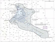
Banana is located on the north coast of the atoll, right by Cassidy Airport . The place is about 12 km from Tabwakea in the eastern part of the island. The only road worth mentioning connects these places and also leads south from Banana along the Bay of Wrecks to the Aeon airfield . About 5 km northwest of the settlement is Cape Mannig and about 4 km east of Northeast Point on the "heel" of the island. Banana is 222 km north of the equator . The main town Napia on the island of Tabuaeran (Fanning Island) is 304 km (northwest direction) away, the island Teraina (Washington Island) 450 km, also in a northwest direction. The capital of Kiribati, South Tarawa on the Tarawa Atoll is 3254 km away. Banana has notable palm forests and the Banana Wells spring . To the south extends a skeleton that is formed by ancient coral reefs and is fragmented by many small arms of the lagoon and the slightly larger Manulu Lagoon .
Individual evidence
- ^ A b Office of Te Beretitenti - Republic of Kiribati Island Report Series: 20th Kiritimati. 2012.
- ^ Report on the Kiribati 2010 Census of Population and Housing. Vol 1: Basic Information and Tables. Part B: Personal (Population) Tables. Table 3: Population by Village, Sex and Age Group - 2010: 50.
Coordinates: 1 ° 59 ′ N , 157 ° 22 ′ W
