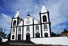
Bandeiras (Madalena)
| Bandeiras | ||||||
|---|---|---|---|---|---|---|
|
||||||
| Basic data | ||||||
| Autonomous Region : | Azores | |||||
| Concelho : | Madalena | |||||
| Coordinates : | 38 ° 32 ′ N , 28 ° 28 ′ W | |||||
| Residents: | 626 (as of June 30, 2011) | |||||
| Surface: | 22.21 km² (as of January 1, 2010) | |||||
| Population density : | 28 inhabitants per km² | |||||
| Postal code : | 9950-021 | |||||
| politics | ||||||
| Mayor : | Emanuel Pereira da Melo ( PSD ) | |||||
| Address of the municipal administration: | Junta de Freguesia de Bandeiras Canada Cruz 9950-021 Bandeiras |
|||||
Bandeiras is a Portuguese municipality ( freguesia ) in the district ( concelho ) of Madalena , on the Azores island of Pico . 626 people live in the municipality (as of June 30, 2011).
The Pico Airport is located in the municipal area.
administration
Bandeiras is the seat of a municipality of the same name ( Freguesia ). The following localities are in the municipality:
- Arcos do Cachorro (Cachorro)
- Bandeiras
- Cais do Mourato
- Cabeço Chão
- Farrobo
- Laje
- Lajinhas
- Mourato
Web links
Commons : Bandeiras - collection of images, videos and audio files
Individual evidence
- ↑ a b www.ine.pt - indicator resident population by place of residence and sex; Decennial in the database of the Instituto Nacional de Estatística
- ↑ Overview of code assignments from Freguesias on epp.eurostat.ec.europa.eu


