
Barú (peninsula)
| Barú peninsula | ||
 The elongated peninsula |
||
| Geographical location | ||
|
||
| Coordinates | 10 ° 8 '38 " N , 75 ° 40' 57" W | |
| Waters 1 | Caribbean | |
 Playa Blanca on Barú |
||

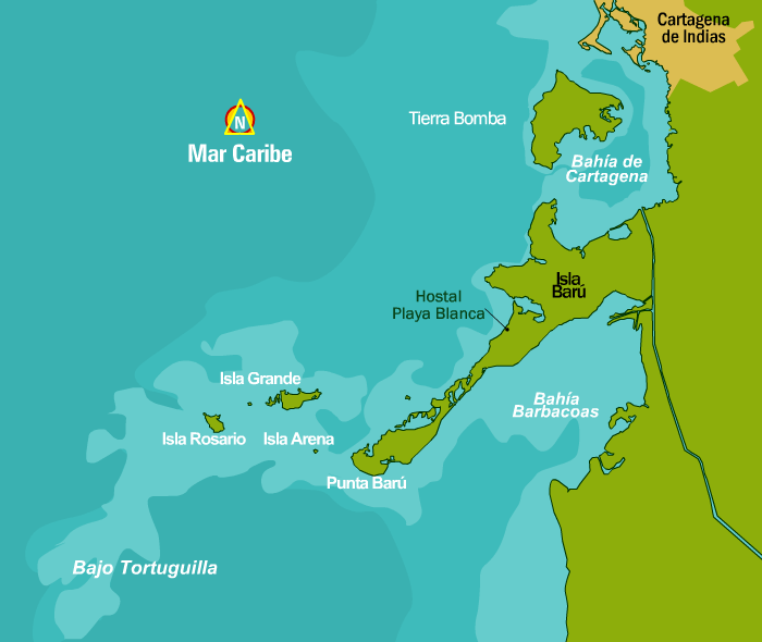
The Barú peninsula ( Spanish Península de Barú ) is located south of the city of Cartagena on the Colombian Caribbean coast in the Department of Bolívar . The El Dique Canal , which connects the Bahía de Cartagena de Indias in the north with the Río Magdalena , passes east of the peninsula . Since the channel practically separates the peninsula from the mainland, it is sometimes referred to as an island ( Isla in Spanish ).
Administratively, Barú belongs to the municipality of Cartagena in the Department of Bolívar .
To the west of Barú are the Islas del Rosario , to the north is the Isla de Tierra Bomba . The Corales del Rosario National Park is located on the peninsula . Near the point in the west, the Punta Barú , which is separated from the rest of the peninsula by a narrow channel, is the place Barú .
The Bahía Barbacoas is located south of Barú .
In 2015, the Spanish galleon San José was found near the peninsula , which was sunk in a naval battle with British warships in 1708 .
Individual evidence
- ↑ Map on caribbeanresorthouses.com
- ↑ [1]
- ↑ a b map on cartagenacaribe.com
- ↑ Tagesschau.de: Galleon "San Jose": 300 year old shipwreck found off Colombia , December 6, 2015 , accessed on August 7, 2019.