Barlavento
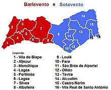
The Barlavento is the western part of the Algarve in southern Portugal. The Portuguese term for wind (o vento) is part of the name for this region. Barlavento means roughly "the side facing the wind" (Luv). Thus, the name of this region refers to the fact that there is a strong wind coming from the sea all year round.
Geography and climate
The Barlavento is the western part of the Algarve. The city of Albufeira , which lies roughly in the middle on the east-west axis of the Algarve, marks the border between the Barlavento and the Sotavento to the east .
The Barlavento is often referred to as the rocky Algarve. The coast is characterized by up to 50 meters high cliffs made of sandstone and limestone. In the cliffs there are always grottos and small bays with sandy beaches. The further west you go, the stronger the wind that constantly comes from the Atlantic becomes. Accordingly, there is strong surf and sometimes strong currents for most of the year.
The wind speed in Sagres, the city in the extreme southwest of Europe, is 19 km / h on an annual average. The probability that a wind force of four Beaufort or more occurs is 39%. The annual average temperature is a pleasant 18 ° C. With 300 sunny days a year, the Barlavento is the sunniest area in Europe. The climatic conditions are related to the exposed location of the Barlavento. The Cabo de São Vicente forms the most south-westerly tip of the world's largest contiguous land mass (Eurasia).
history
In the 15th and 16th centuries, Portuguese seafarers advanced into previously unknown areas of the world, making the country the leading colonial and trading power. The history of Portuguese seafaring started in Barlavento. Heinrich the Navigator founded a seafaring school near Sagres at the beginning of the 15th century. The first and largest slave market in the world developed in Lagos, today one of the strongholds of tourism in Barlavento .
Administration and settlement
The Barlavento is divided into 8 administrative districts (Portuguese: Municípios). These are:
The largest cities are Portimão with 36,200 inhabitants (as of 2001), Albufeira with 31,543 inhabitants (as of 2001) and Lagos with 28,890 inhabitants (as of 2009). Outside of these metropolitan areas, the population density is low. Especially the districts west of Lagos and the hinterland are only sparsely populated. Here you can still often find huge deserted areas. The city of Sagres, located on the Cape of St. Vincent, is the largest city in the region with 1,939 inhabitants (as of 2001). In the Aljezur district there are just 16 people per km².
tourism
Tourism forms the economic basis of the Barlavento. In the summer months there are around three times as many tourists as residents in the region. Tourism is mainly concentrated in the largest districts of Portimão, Albufeira and Lagos. Individual tourism is of far greater importance. Outside the cities, medium-sized to large holiday villas in well-maintained complexes dominate the picture.
The western part of Barlaventos (districts of Vila do Bispo and Aljezur) has hardly been developed until now. Only the Cape of St. Vincent attracts tens of thousands of tourists every year. Because of the few people who visit the beaches and because of the strong winds associated with high waves, the region is known throughout Europe among windsurfers , kite surfers and surfers . The Barlavento is also a paradise for sailors. The golf courses and golf resorts that can be found all over Barlavento are also popular with connoisseurs.


