Barro Colorado Island
| Barro Colorado Island | ||
|---|---|---|
| Waters | Gatunsee | |
| Geographical location | 9 ° 9 ′ 0 ″ N , 79 ° 51 ′ 0 ″ W | |
|
|
||
| length | 3 km | |
| width | 5.4 km | |
| surface | 15 km² | |
| Residents | 200 13 inhabitants / km² |
|

Barro Colorado Island is an artificial island , created by the damming of the Panama Canal in 1914. Barro Colorado Island is also the largest island in the Gatun Sea with 15 km² , which is part of the Panama Canal in the central interior of Panama .
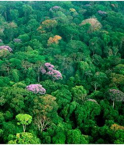
The island is completely covered by tropical rainforest ( semi-humid deciduous forest ) and has been administered by the Smithsonian Institution since 1946 according to bilateral agreements . From 1923, when the island was designated a biological reserve, until 1946, BCI was administered by the National Academy of Sciences . Barro Colorado Island is now considered to be the best-researched tropical ecosystem in the world.
Barro Colorado is protected as a natural monument. The island only houses a police station and a research station of the Smithsonian Tropical Research Institute (STRI), where around 200 international scientists work throughout the year.
Geography and geology
The name Barro Colorado comes from the Spanish and means something like red clay . The name thus describes soil color and soil type that can be found in large parts of BCI.
The highest point on the island is 165 m above sea level or 140 m above Lake Gatùn. The relief has a gentle slope that is only a few places steeper than 10 °.
The few outcrops that can be found on BCI are mostly in stream beds . The rock formations date back to the early Oligocene . A total of three formations can be differentiated on BCI:
The Bohio rock layer serves as the basis for the other two formations and is also the oldest of the three (early Oligocene).
climate
From May to November BCI experiences, like the rest of Panama, a rainy season that usually reaches its peak in October / November. The rest of the year (December to April) is the dry season.
The temperature fluctuates between 21 ° C and 32 ° C throughout the year. In 1926 the relative humidity fluctuated between 88% (June, July, August) and 77% (January, February, March). After Köppen , BCI is in the Am zone ( rainforest climate despite a dry season )
vegetation
Half of the forest on BCI consists of primary forest with an age of approx. 200–400 years. The other half, facing the Panama Canal, consists of secondary forest , which is significantly younger at 100 years. This is attributed to the clearing and agriculture that was carried out there before the Gatúnsee was dammed.
7% of the 1314 plant species on BCI are found in Panama alone.
credentials
- ↑ a b c d L. A. Kenoyer: General and successional ecology of the lower tropical rain-forest at Barro Colorado Island, Panama. Ecological Society of America, 1928.
- ^ A b c I. Baillie et al .: Semi-detailed soil survey of Barro Colorado Island, Panama. (PDF; 5.9 MB). STRI, 2007.
- ↑ Profile BCI from STRI ( Memento of the original from January 4, 2012 in the Internet Archive ) Info: The archive link was inserted automatically and has not yet been checked. Please check the original and archive link according to the instructions and then remove this notice. (English)
- ^ A b c Thomas B. Croat: Flora of Barro Colorado Island. Stanford University Press, 1978.
- ^ Donald M. Windsor: Climate and Moisture Variability in a Tropical Forest: Long-term Records from Barro Colorado Island, Panamá. 1990.
- ↑ Vegetation on BCI ( Memento from July 18, 2012 in the web archive archive.today ) (English)

