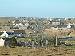
Barvas
|
Barvas Scottish Gaelic Barabhas |
||
|---|---|---|
| View over the village | ||
| Coordinates | 58 ° 21 ′ N , 6 ° 31 ′ W | |
|
|
||
| administration | ||
| Post town | ISLE OF LEWIS | |
| ZIP code section | HS2 | |
| prefix | 01851 | |
| Part of the country | Scotland | |
| Council area | Outer Hebrides | |
| British Parliament | Na h-Eileanan to Iar | |
| Scottish Parliament | Na h-Eileanan to Iar | |
Barvas (Scottish Gaelic: Barabhas or Barbhas ) is a community on the outer Hebridean island of Lewis in Scotland . The name is of Old Norse origin like many settlement names in the Hebrides. Its meaning is unclear, however. There has been a parish book since 1810 in which baptisms and weddings as well as alms to the needy were regularly documented.
The community had 2037 inhabitants in 2011 and is located at the intersection of the A 857 and A 858. The road leads north to Ness , west to Carloway , south to Stornoway . According to the 2011 census, the parish has the highest concentration of Scottish Gaelic speakers in Scotland (64% of the population). In the 2001 census, 73% of residents said they spoke Scottish Gaelic on a daily basis.
At the beginning of the new millennium there was a controversy over the construction of Europe's largest wind farm , which was planned in Barvas Moor. The Scottish government rejected the proposal in 2008, however.
Individual evidence
- ↑ http://www.scottish.parliament.uk/Gaelic/placenamesA-B.pdf Retrieved February 13, 2016
- ↑ http://www.scotlandsplaces.gov.uk/search/gazetteer/Barvas Retrieved February 13, 2016
- ↑ http://news.bbc.co.uk/2/hi/uk_news/scotland/highlands_and_islands/7208991.stm Retrieved February 13, 2016

