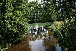
Bayas (river)
| Río Bayas | ||
|
Mouth of the Río Baias (brown) into the Ebro (green) |
||
| Data | ||
| location | Province of Alava , (Spain) | |
| River system | Ebro | |
| Drain over | Ebro → Mediterranean | |
| source | at the foot of Monte Gorbea 43 ° 1 ′ 36 ″ N , 2 ° 49 ′ 40 ″ W |
|
| Source height | 1190 msnm | |
| muzzle | at Miranda de Ebro in the Ebro coordinates: 42 ° 40 ′ 31 ″ N , 2 ° 55 ′ 45 ″ W 42 ° 40 ′ 31 ″ N , 2 ° 55 ′ 45 ″ W. |
|
| Mouth height | 468 msnm | |
| Height difference | 722 m | |
| Bottom slope | 21 ‰ | |
| length | 35 km | |
| Communities | Miranda de Ebro | |
The Río Bayas (also written Río Baias ; Basque : Baia ) is a tributary of the Ebro in the northern Spanish province of Álava in the Basque Country Autonomous Region . It is the largest river in the province of Álava.
geography
The Río Bayas rises on the southern slope of Monte Gorbea , the highest point in the province of Álava at 1,482 meters. It flows through the municipalities ( municipios ) of Cuartango , Ribera Alta and Lantarón in a north-south direction and flows south of the town of Miranda de Ebro ( Burgos province ) into the Ebro.
Tributaries
Apart from a few streams, the Río Bayas has no major tributaries.
places
Attractions
On the banks of the Río Bayas there are - apart from a menhir at Zastegi - only scenic sights. The area is good for hiking; If the weather is nice, it is also possible to climb to the top of Monte Gorbea; the mountain is also surrounded by a natural park ( Parque natural de Gorbea ).

